Wittgensdorf geodata
Wittgensdorf (Saxony) is a populated place; located in Germany in Europe/Berlin (GMT+2) time zone. With population of 4,440 people, there are 3068 cities with bigger population in this country. Compared to other cities in Germany, 55.7% of cities are located further ↓South; 91.2% of cities are located further ←West and 63.6% of cities have lower elevation than Wittgensdorf. Note1


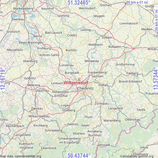
Wittgensdorf GPS coordinates[2]
50° 52' 59.376" North, 12° 52' 13.116" East
| Map corner | latitude | longitude |
|---|---|---|
| Upper-left | 51.32465°, | 12.16719° |
| Center: | 50.88316°, | 12.87031° |
| Lower-right: | 50.43744°, | 13.57344° |
| Map W x H: | 98.6×98.6 km | = 61.3×61.3mi |
| max Lat: | 55.01917° ⇑44.3% North |
| Wittgensdorf: | 50.88316° |
| min Lat: | ⇓55.7% South 47.40724° |
| min Long | Wittgensdorf | max Long |
| 5.92978° | 12.87031° | 14.98853° |
| W 91.2%⇐ | ⇒8.8% E |
Elevation
Elevation of Wittgensdorf is 312 m = 1024 ft, and this is 62.9 m = 206 ft above average elevation for this country.
| Max E: |
1256 m = 4121 ft | 36.4% |
| Wittgensdorf | 312 m 1024 ft | |
| Avg. | 249.1 m = 817 ft | |
Min E: |
-5 m = -16 ft | 63.6% |
See also: Germany elevation on elevation.city.
Geographical zone
Wittgensdorf is located in North temperate zone (between Tropic of Cancer and the Arctic Circle). Distance of this North polar circle is 1743.5 km =1083.4 mi to North.| Distance of | km | miles | from Wittgensdorf |
|---|---|---|---|
| North Pole | 4349.4 | 2702.6 | to North |
| Arctic Circle | 1743.5 | 1083.4 | to North |
| Tropic Cancer | 3051.8 | 1896.3 | to South |
| Equator | 5657.7 | 3515.5 | to South |


Nearby cities:
15 places around Wittgensdorf: (largest is in red/bold)
• Altmittweida
10.8 km =6.7 mi,  31°
31°
• Burgstädt
5.6 km =3.5 mi,  306°
306°
• Chemnitz
6.7 km =4.2 mi,  141°
141°
• Claußnitz
5.7 km =3.5 mi,  9°
9°
• Frankenberg
12.4 km =7.7 mi,  74°
74°
• Hartmannsdorf
5.3 km =3.3 mi,  290°
290°
• Hilbersdorf
6.3 km =3.9 mi,  120°
120°
• Limbach-Oberfrohna
8.1 km =5 mi,  250°
250°
• Lunzenau
11.9 km =7.4 mi,  317°
317°
• Mühlau
7.5 km =4.7 mi,  284°
284°
• Neukirchen
11.5 km =7.1 mi,  180°
180°
• Niederfrohna
10.9 km =6.8 mi, 279°
• Niederwiesa
10.4 km =6.5 mi,  100°
100°
• Penig
12.9 km =8 mi,  295°
295°
• Taura
4 km =2.5 mi,  339°
339°
Sources, notices
• [Note1] Compared only with cities in Germany existing in our database
• [Src1] Map data: © OpenStreetMap contributors (CC-BY-SA)
• [Src2] Other city data from geonames.org with taken over terms of usage.
• [Src3] Geographical zone / Annual Mean Temperature by Robert A. Rohde @ Wikipedia
