Limbach-Oberfrohna geodata
Limbach-Oberfrohna (Saxony) is a populated place; located in Germany in Europe/Berlin (GMT+2) time zone. With population of 27,056 people, there are 531 cities with bigger population in this country. Compared to other cities in Germany, 55.3% of cities are located further ↓South; 90.4% of cities are located further ←West and 70% of cities have lower elevation than Limbach-Oberfrohna. Note1


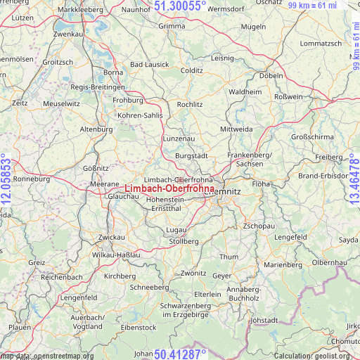
Limbach-Oberfrohna GPS coordinates[2]
50° 51' 31.752" North, 12° 45' 41.94" East
| Map corner | latitude | longitude |
|---|---|---|
| Upper-left | 51.30055°, | 12.05853° |
| Center: | 50.85882°, | 12.76165° |
| Lower-right: | 50.41287°, | 13.46478° |
| Map W x H: | 98.7×98.7 km | = 61.3×61.3mi |
| max Lat: | 55.01917° ⇑44.7% North |
| Limbach-Oberfrohna: | 50.85882° |
| min Lat: | ⇓55.3% South 47.40724° |
| min Long | Limbach-Oberfro | max Long |
| 5.92978° | 12.76165° | 14.98853° |
| W 90.4%⇐ | ⇒9.6% E |
Elevation
Elevation of Limbach-Oberfrohna is 358 m = 1175 ft, and this is 108.9 m = 357 ft above average elevation for this country.
| Max E: |
1256 m = 4121 ft | 30% |
| Limbach-Oberfrohna | 358 m 1175 ft | |
| Avg. | 249.1 m = 817 ft | |
Min E: |
-5 m = -16 ft | 70% |
See also: Germany elevation on elevation.city.
Geographical zone
Limbach-Oberfrohna is located in North temperate zone (between Tropic of Cancer and the Arctic Circle). Distance of this North polar circle is 1746.2 km =1085 mi to North.| Distance of | km | miles | from Limbach-Oberfrohna |
|---|---|---|---|
| North Pole | 4352.1 | 2704.3 | to North |
| Arctic Circle | 1746.2 | 1085 | to North |
| Tropic Cancer | 3049.1 | 1894.6 | to South |
| Equator | 5655 | 3513.9 | to South |


Nearby cities:
15 places around Limbach-Oberfrohna: (largest is in red/bold)
• Burgstädt
6.8 km =4.2 mi,  27°
27°
• Callenberg
9.1 km =5.7 mi,  263°
263°
• Claußnitz
11.9 km =7.4 mi,  45°
45°
• Hartmannsdorf
5.3 km =3.3 mi, 30°
• Hohenstein-Ernstthal
7.3 km =4.5 mi,  207°
207°
• Kirchberg
10.8 km =6.7 mi,  178°
178°
• Lunzenau
11.6 km =7.2 mi,  358°
358°
• Mühlau
4.6 km =2.9 mi,  4°
4°
• Neukirchen
11.5 km =7.1 mi,  139°
139°
• Niederfrohna
5.6 km =3.5 mi,  325°
325°
• Oberlungwitz
9.3 km =5.8 mi,  203°
203°
• Penig
9.2 km =5.7 mi, 334°
• Taura
8.9 km =5.5 mi,  43°
43°
• Waldenburg
11.6 km =7.2 mi,  279°
279°
• Wittgensdorf
8.1 km =5 mi,  70°
70°
Sources, notices
• [Note1] Compared only with cities in Germany existing in our database
• [Src1] Map data: © OpenStreetMap contributors (CC-BY-SA)
• [Src2] Other city data from geonames.org with taken over terms of usage.
• [Src3] Geographical zone / Annual Mean Temperature by Robert A. Rohde @ Wikipedia
