Lunzenau geodata
Lunzenau (Saxony) is a populated place; located in Germany in Europe/Berlin (GMT+2) time zone. With population of 5,138 people, there are 2775 cities with bigger population in this country. Compared to other cities in Germany, 57.4% of cities are located further ↓South; 90.4% of cities are located further ←West and 55.9% of cities have higher elevation than Lunzenau. Note1


Lunzenau GPS coordinates[2]
50° 57' 45.684" North, 12° 45' 21.384" East
| Map corner | latitude | longitude |
|---|---|---|
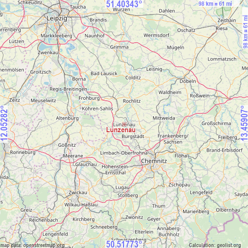
| Upper-left | 51.40343°, | 12.05282° |
| Center: | 50.96269°, | 12.75594° |
| Lower-right: | 50.51773°, | 13.45907° |
| Map W x H: | 98.5×98.5 km | = 61.2×61.2mi |
| max Lat: | 55.01917° ⇑42.6% North |
| Lunzenau: | 50.96269° |
| min Lat: | ⇓57.4% South 47.40724° |
| min Long | Lunzenau | max Long |
| 5.92978° | 12.75594° | 14.98853° |
| W 90.4%⇐ | ⇒9.6% E |
Elevation
Elevation of Lunzenau is 182 m = 597 ft, and this is 67.1 m = 220 ft below average elevation for this country.
| Max E: |
1256 m = 4121 ft | 55.9% |
| Avg. | 249.1 m = 817 ft | |
| Lunzenau | 182 m = 597 ft | |
Min E: |
-5 m = -16 ft | 44.1% |
See also: Germany elevation on elevation.city.
Geographical zone
Lunzenau is located in North temperate zone (between Tropic of Cancer and the Arctic Circle). Distance of this North polar circle is 1734.7 km =1077.9 mi to North.| Distance of | km | miles | from Lunzenau |
|---|---|---|---|
| North Pole | 4340.5 | 2697.1 | to North |
| Arctic Circle | 1734.7 | 1077.9 | to North |
| Tropic Cancer | 3060.6 | 1901.8 | to South |
| Equator | 5666.5 | 3521 | to South |


Nearby cities:
15 places around Lunzenau: (largest is in red/bold)
• Burgstädt
6.5 km =4 mi,  147°
147°
• Claußnitz
9.5 km =5.9 mi,  110°
110°
• Geithain
11.1 km =6.9 mi,  338°
338°
• Hartmannsdorf
7.6 km =4.7 mi,  156°
156°
• Jückelberg
9.7 km =6 mi,  245°
245°
• Königsfeld
11.6 km =7.2 mi,  357°
357°
• Limbach-Oberfrohna
11.6 km =7.2 mi,  178°
178°
• Mühlau
7 km =4.3 mi,  173°
173°
• Narsdorf
6.6 km =4.1 mi, 335°
• Niederfrohna
7.5 km =4.7 mi,  201°
201°
• Penig
4.9 km =3 mi,  228°
228°
• Rochlitz
10.1 km =6.3 mi,  16°
16°
• Seelitz
8.9 km =5.5 mi,  28°
28°
• Taura
8.3 km =5.2 mi,  127°
127°
• Wechselburg
4.6 km =2.9 mi, 18°
Sources, notices
• [Note1] Compared only with cities in Germany existing in our database
• [Src1] Map data: © OpenStreetMap contributors (CC-BY-SA)
• [Src2] Other city data from geonames.org with taken over terms of usage.
• [Src3] Geographical zone / Annual Mean Temperature by Robert A. Rohde @ Wikipedia
