Chemnitz geodata
Chemnitz (Saxony) is a seat of a third-order administrative division; located in Germany in Europe/Berlin (GMT+2) time zone. With population of 247,220 people, there are 33 cities with bigger population in this country. Compared to other cities in Germany, 54.9% of cities are located further ↓South; 91.7% of cities are located further ←West and 62.7% of cities have lower elevation than Chemnitz. Note1


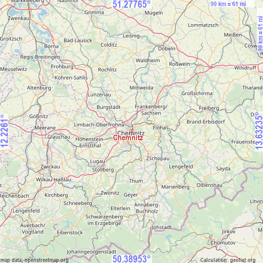
Chemnitz GPS coordinates[2]
50° 50' 8.52" North, 12° 55' 45.192" East
| Map corner | latitude | longitude |
|---|---|---|
| Upper-left | 51.27765°, | 12.2261° |
| Center: | 50.8357°, | 12.92922° |
| Lower-right: | 50.38953°, | 13.63235° |
| Map W x H: | 98.7×98.7 km | = 61.3×61.3mi |
| max Lat: | 55.01917° ⇑45.1% North |
| Chemnitz: | 50.8357° |
| min Lat: | ⇓54.9% South 47.40724° |
| min Long | Chemnitz | max Long |
| 5.92978° | 12.92922° | 14.98853° |
| W 91.7%⇐ | ⇒8.3% E |
Elevation
Elevation of Chemnitz is 306 m = 1004 ft, and this is 56.9 m = 187 ft above average elevation for this country.
| Max E: |
1256 m = 4121 ft | 37.3% |
| Chemnitz | 306 m 1004 ft | |
| Avg. | 249.1 m = 817 ft | |
Min E: |
-5 m = -16 ft | 62.7% |
See also: Chemnitz elevation on elevation.city.
Geographical zone
Chemnitz is located in North temperate zone (between Tropic of Cancer and the Arctic Circle). Distance of this North polar circle is 1748.8 km =1086.7 mi to North.| Distance of | km | miles | from Chemnitz |
|---|---|---|---|
| North Pole | 4354.7 | 2705.9 | to North |
| Arctic Circle | 1748.8 | 1086.7 | to North |
| Tropic Cancer | 3046.5 | 1893 | to South |
| Equator | 5652.4 | 3512.2 | to South |


Nearby cities:
15 places around Chemnitz: (largest is in red/bold)
• Augustusburg
12.4 km =7.7 mi,  102°
102°
• Burgstädt
12.2 km =7.6 mi,  314°
314°
• Burkhardtsdorf
11.4 km =7.1 mi,  184°
184°
• Claußnitz
11.3 km =7 mi,  343°
343°
• Flöha
10.4 km =6.5 mi,  77°
77°
• Frankenberg
11.6 km =7.2 mi,  42°
42°
• Gornau
11.4 km =7.1 mi,  138°
138°
• Hartmannsdorf
11.5 km =7.1 mi, 308°
• Hilbersdorf
2.4 km =1.5 mi,  32°
32°
• Jahnsdorf
11.4 km =7.1 mi,  207°
207°
• Limbach-Oberfrohna
12 km =7.5 mi,  282°
282°
• Neukirchen
7.6 km =4.7 mi, 214°
• Niederwiesa
7 km =4.3 mi,  60°
60°
• Taura
10.6 km =6.6 mi,  328°
328°
• Wittgensdorf
6.7 km =4.2 mi,  321°
321°
Sources, notices
• [Note1] Compared only with cities in Germany existing in our database
• [Src1] Map data: © OpenStreetMap contributors (CC-BY-SA)
• [Src2] Other city data from geonames.org with taken over terms of usage.
• [Src3] Geographical zone / Annual Mean Temperature by Robert A. Rohde @ Wikipedia
