Taura geodata
Taura (Saxony) is a seat of a fourth-order administrative division; located in Germany in Europe/Berlin (GMT+2) time zone. With population of 2,609 people, there are 4322 cities with bigger population in this country. Compared to other cities in Germany, 56.4% of cities are located further ↓South; 91.1% of cities are located further ←West and 61.3% of cities have lower elevation than Taura. Note1


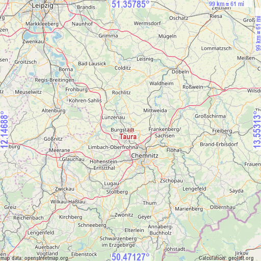
Taura GPS coordinates[2]
50° 55' 0.012" North, 12° 51' 0" East
| Map corner | latitude | longitude |
|---|---|---|
| Upper-left | 51.35785°, | 12.14688° |
| Center: | 50.91667°, | 12.85° |
| Lower-right: | 50.47127°, | 13.55313° |
| Map W x H: | 98.6×98.6 km | = 61.3×61.3mi |
| max Lat: | 55.01917° ⇑43.6% North |
| Taura: | 50.91667° |
| min Lat: | ⇓56.4% South 47.40724° |
| min Long | Taura | max Long |
| 5.92978° | 12.85° | 14.98853° |
| W 91.1%⇐ | ⇒8.9% E |
Elevation
Elevation of Taura is 298 m = 978 ft, and this is 48.9 m = 160 ft above average elevation for this country.
| Max E: |
1256 m = 4121 ft | 38.7% |
| Taura | 298 m 978 ft | |
| Avg. | 249.1 m = 817 ft | |
Min E: |
-5 m = -16 ft | 61.3% |
See also: Germany elevation on elevation.city.
Geographical zone
Taura is located in North temperate zone (between Tropic of Cancer and the Arctic Circle). Distance of this North polar circle is 1739.8 km =1081.1 mi to North.| Distance of | km | miles | from Taura |
|---|---|---|---|
| North Pole | 4345.7 | 2700.3 | to North |
| Arctic Circle | 1739.8 | 1081.1 | to North |
| Tropic Cancer | 3055.5 | 1898.6 | to South |
| Equator | 5661.4 | 3517.8 | to South |


Nearby cities:
15 places around Taura: (largest is in red/bold)
• Altmittweida
8.9 km =5.5 mi,  51°
51°
• Burgstädt
3.1 km =1.9 mi,  263°
263°
• Chemnitz
10.6 km =6.6 mi,  148°
148°
• Claußnitz
3 km =1.9 mi, 51°
• Erlau
12.3 km =7.6 mi,  32°
32°
• Hartmannsdorf
4 km =2.5 mi,  242°
242°
• Hilbersdorf
9.8 km =6.1 mi,  135°
135°
• Limbach-Oberfrohna
8.9 km =5.5 mi,  223°
223°
• Lunzenau
8.3 km =5.2 mi,  307°
307°
• Mittweida
11.7 km =7.3 mi, 48°
• Mühlau
6.1 km =3.8 mi,  252°
252°
• Niederfrohna
9.5 km =5.9 mi, 258°
• Penig
10.4 km =6.5 mi,  280°
280°
• Wechselburg
10.8 km =6.7 mi,  331°
331°
• Wittgensdorf
4 km =2.5 mi,  159°
159°
Sources, notices
• [Note1] Compared only with cities in Germany existing in our database
• [Src1] Map data: © OpenStreetMap contributors (CC-BY-SA)
• [Src2] Other city data from geonames.org with taken over terms of usage.
• [Src3] Geographical zone / Annual Mean Temperature by Robert A. Rohde @ Wikipedia
