Herne geodata
Herne (North Rhine-Westphalia) is a seat of a third-order administrative division; located in Germany in Europe/Berlin (GMT+2) time zone. With population of 172,108 people, there are 52 cities with bigger population in this country. Compared to other cities in Germany, 66.8% of cities are located further ↓South; 91.1% of cities are located further →East and 74.1% of cities have higher elevation than Herne. Note1
Administrative division(s):
- Level 1: North Rhine-Westphalia
- Level 2: Regierungsbezirk Arnsberg
- Level 3: Kreisfreie Stadt Herne
- Level 4: Herne


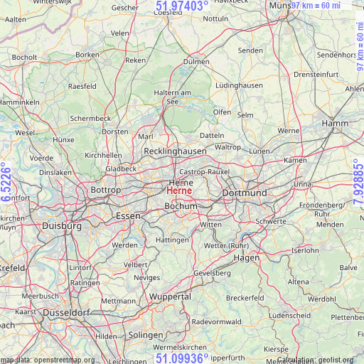
Herne GPS coordinates[2]
51° 32' 19.68" North, 7° 13' 32.592" East
| Map corner | latitude | longitude |
|---|---|---|
| Upper-left | 51.97403°, | 6.5226° |
| Center: | 51.5388°, | 7.22572° |
| Lower-right: | 51.09936°, | 7.92885° |
| Map W x H: | 97.3×97.3 km | = 60.5×60.5mi |
| max Lat: | 55.01917° ⇑33.2% North |
| Herne: | 51.5388° |
| min Lat: | ⇓66.8% South 47.40724° |
| min Long | Herne | max Long |
| 5.92978° | 7.22572° | 14.98853° |
| W 8.9%⇐ | ⇒91.1% E |
Elevation
Elevation of Herne is 67 m = 220 ft, and this is 182.1 m = 597 ft below average elevation for this country.
| Max E: |
1256 m = 4121 ft | 74.1% |
| Avg. | 249.1 m = 817 ft | |
| Herne | 67 m = 220 ft | |
Min E: |
-5 m = -16 ft | 25.9% |
See also: Herne elevation on elevation.city.
Geographical zone
Herne is located in North temperate zone (between Tropic of Cancer and the Arctic Circle). Distance of this North polar circle is 1670.6 km =1038.1 mi to North.| Distance of | km | miles | from Herne |
|---|---|---|---|
| North Pole | 4276.5 | 2657.3 | to North |
| Arctic Circle | 1670.6 | 1038.1 | to North |
| Tropic Cancer | 3124.7 | 1941.6 | to South |
| Equator | 5730.6 | 3560.8 | to South |


Nearby cities:
15 places around Herne: (largest is in red/bold)
• Bochum
6.4 km =4 mi,  185°
185°
• Bochum-Hordel
5.4 km =3.4 mi,  220°
220°
• Castrop-Rauxel
6.3 km =3.9 mi,  71°
71°
• Datteln
15.4 km =9.6 mi,  32°
32°
• Dortmund
16.8 km =10.4 mi,  99°
99°
• Gelsenkirchen
9.7 km =6 mi,  247°
247°
• Gladbeck
17 km =10.6 mi,  282°
282°
• Hattingen
15.8 km =9.8 mi, 190°
• Herten
8.5 km =5.3 mi,  318°
318°
• Hordel
5.7 km =3.5 mi, 216°
• Marl
16.1 km =10 mi, 324°
• Oer-Erkenschwick
11.8 km =7.3 mi,  13°
13°
• Recklinghausen
8.6 km =5.3 mi,  346°
346°
• Waltrop
15.3 km =9.5 mi,  53°
53°
• Witten
13.8 km =8.6 mi,  140°
140°
Sources, notices
• [Note1] Compared only with cities in Germany existing in our database
• [Src1] Map data: © OpenStreetMap contributors (CC-BY-SA)
• [Src2] Other city data from geonames.org with taken over terms of usage.
• [Src3] Geographical zone / Annual Mean Temperature by Robert A. Rohde @ Wikipedia
