Bochum-Hordel geodata
Bochum-Hordel (North Rhine-Westphalia) is a section of populated place; located in Germany in Europe/Berlin (GMT+2) time zone. With population of 380,000 people, there are 17 cities with bigger population in this country. Compared to other cities in Germany, 66.3% of cities are located further ↓South; 91.7% of cities are located further →East and 76.7% of cities have higher elevation than Bochum-Hordel. Note1
Administrative division(s):
- Level 1: North Rhine-Westphalia
- Level 2: Regierungsbezirk Arnsberg
- Level 3: Kreisfreie Stadt Bochum
- Level 4: Bochum


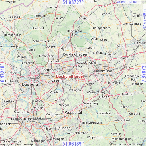
Bochum-Hordel GPS coordinates[2]
51° 30' 6.048" North, 7° 10' 32.16" East
| Map corner | latitude | longitude |
|---|---|---|
| Upper-left | 51.93727°, | 6.47248° |
| Center: | 51.50168°, | 7.1756° |
| Lower-right: | 51.06189°, | 7.87873° |
| Map W x H: | 97.3×97.3 km | = 60.5×60.5mi |
| max Lat: | 55.01917° ⇑33.7% North |
| Bochum-Hordel: | 51.50168° |
| min Lat: | ⇓66.3% South 47.40724° |
| min Long | Bochum-Hordel | max Long |
| 5.92978° | 7.1756° | 14.98853° |
| W 8.3%⇐ | ⇒91.7% E |
Elevation
Elevation of Bochum-Hordel is 57 m = 187 ft, and this is 192.1 m = 630 ft below average elevation for this country.
| Max E: |
1256 m = 4121 ft | 76.7% |
| Avg. | 249.1 m = 817 ft | |
| Bochum-Hordel | 57 m = 187 ft | |
Min E: |
-5 m = -16 ft | 23.3% |
See also: Bochum-Hordel elevation on elevation.city.
Geographical zone
Bochum-Hordel is located in North temperate zone (between Tropic of Cancer and the Arctic Circle). Distance of this North polar circle is 1674.7 km =1040.6 mi to North.| Distance of | km | miles | from Bochum-Hordel |
|---|---|---|---|
| North Pole | 4280.6 | 2659.8 | to North |
| Arctic Circle | 1674.7 | 1040.6 | to North |
| Tropic Cancer | 3120.5 | 1939 | to South |
| Equator | 5726.5 | 3558.3 | to South |


Nearby cities:
15 places around Bochum-Hordel: (largest is in red/bold)
• Bochum
3.6 km =2.2 mi,  128°
128°
• Bottrop
17.3 km =10.7 mi,  278°
278°
• Castrop-Rauxel
11.2 km =7 mi,  57°
57°
• Essen
12.4 km =7.7 mi,  246°
246°
• Gelsenkirchen
5.5 km =3.4 mi,  273°
273°
• Gladbeck
15.2 km =9.4 mi,  300°
300°
• Hattingen
11.4 km =7.1 mi,  176°
176°
• Herne
5.4 km =3.4 mi,  40°
40°
• Herten
10.8 km =6.7 mi,  348°
348°
• Hordel
0.4 km =0.2 mi,  174°
174°
• Marl
18.2 km =11.3 mi,  341°
341°
• Oer-Erkenschwick
16.8 km =10.4 mi,  21°
21°
• Recklinghausen
12.6 km =7.8 mi,  6°
6°
• Sprockhövel
17.9 km =11.1 mi,  164°
164°
• Witten
13.9 km =8.6 mi,  117°
117°
Sources, notices
• [Note1] Compared only with cities in Germany existing in our database
• [Src1] Map data: © OpenStreetMap contributors (CC-BY-SA)
• [Src2] Other city data from geonames.org with taken over terms of usage.
• [Src3] Geographical zone / Annual Mean Temperature by Robert A. Rohde @ Wikipedia
