Wingst geodata
Wingst (Lower Saxony) is a populated locality; located in Germany in Europe/Berlin (GMT+2) time zone. With population of 3,610 people, there are 3532 cities with bigger population in this country. Compared to other cities in Germany, 89.2% of cities are located further ↓South; 64.3% of cities are located further →East and 86.3% of cities have higher elevation than Wingst. Note1


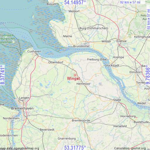
Wingst GPS coordinates[2]
53° 44' 8.592" North, 9° 4' 49.944" East
| Map corner | latitude | longitude |
|---|---|---|
| Upper-left | 54.14957°, | 8.37741° |
| Center: | 53.73572°, | 9.08054° |
| Lower-right: | 53.31775°, | 9.78366° |
| Map W x H: | 92.5×92.5 km | = 57.5×57.5mi |
| max Lat: | 55.01917° ⇑10.8% North |
| Wingst: | 53.73572° |
| min Lat: | ⇓89.2% South 47.40724° |
| min Long | Wingst | max Long |
| 5.92978° | 9.08054° | 14.98853° |
| W 35.7%⇐ | ⇒64.3% E |
Elevation
Elevation of Wingst is 32 m = 105 ft, and this is 217.1 m = 712 ft below average elevation for this country.
| Max E: |
1256 m = 4121 ft | 86.3% |
| Avg. | 249.1 m = 817 ft | |
| Wingst | 32 m = 105 ft | |
Min E: |
-5 m = -16 ft | 13.7% |
See also: Germany elevation on elevation.city.
Geographical zone
Wingst is located in North temperate zone (between Tropic of Cancer and the Arctic Circle). Distance of this North polar circle is 1426.3 km =886.3 mi to North.| Distance of | km | miles | from Wingst |
|---|---|---|---|
| North Pole | 4032.2 | 2505.5 | to North |
| Arctic Circle | 1426.3 | 886.3 | to North |
| Tropic Cancer | 3368.9 | 2093.3 | to South |
| Equator | 5974.9 | 3712.6 | to South |


Nearby cities:
15 places around Wingst: (largest is in red/bold)
• Balje
11.4 km =7.1 mi,  17°
17°
• Belum
10.4 km =6.5 mi,  329°
329°
• Bülkau
6.8 km =4.2 mi,  279°
279°
• Cadenberge
3.9 km =2.4 mi,  342°
342°
• Geversdorf
7.1 km =4.4 mi,  1°
1°
• Hemmoor
7.3 km =4.5 mi,  137°
137°
• Ihlienworth
10.8 km =6.7 mi,  268°
268°
• Lamstedt
11.5 km =7.1 mi,  173°
173°
• Mittelstenahe
10 km =6.2 mi,  198°
198°
• Neuhaus an der Oste
7.8 km =4.8 mi, 336°
• Oberndorf
4.8 km =3 mi,  70°
70°
• Odisheim
10.1 km =6.3 mi,  243°
243°
• Osten
8.8 km =5.5 mi,  116°
116°
• Osterbruch
10.3 km =6.4 mi,  297°
297°
• Stinstedt
10.9 km =6.8 mi,  220°
220°
Sources, notices
• [Note1] Compared only with cities in Germany existing in our database
• [Src1] Map data: © OpenStreetMap contributors (CC-BY-SA)
• [Src2] Other city data from geonames.org with taken over terms of usage.
• [Src3] Geographical zone / Annual Mean Temperature by Robert A. Rohde @ Wikipedia
