Balje geodata
Balje (Lower Saxony) is a seat of a fourth-order administrative division; located in Germany in Europe/Berlin (GMT+2) time zone. With population of 1,109 people, there are 6824 cities with bigger population in this country. Compared to other cities in Germany, 90.4% of cities are located further ↓South; 63.5% of cities are located further →East and 99.1% of cities have higher elevation than Balje. Note1


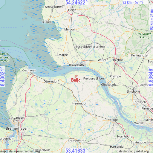
Balje GPS coordinates[2]
53° 49' 59.988" North, 9° 7' 59.988" East
| Map corner | latitude | longitude |
|---|---|---|
| Upper-left | 54.24622°, | 8.43021° |
| Center: | 53.83333°, | 9.13333° |
| Lower-right: | 53.41633°, | 9.83646° |
| Map W x H: | 92.3×92.3 km | = 57.4×57.4mi |
| max Lat: | 55.01917° ⇑9.6% North |
| Balje: | 53.83333° |
| min Lat: | ⇓90.4% South 47.40724° |
| min Long | Balje | max Long |
| 5.92978° | 9.13333° | 14.98853° |
| W 36.5%⇐ | ⇒63.5% E |
Elevation
Elevation of Balje is 0 m = 0 ft, and this is 249.1 m = 817 ft below average elevation for this country.
| Max E: |
1256 m = 4121 ft | 99.1% |
| Avg. | 249.1 m = 817 ft | |
| Balje | 0 m = 0 ft | |
Min E: |
-5 m = -16 ft | 0.9% |
See also: Germany elevation on elevation.city.
Geographical zone
Balje is located in North temperate zone (between Tropic of Cancer and the Arctic Circle). Distance of this North polar circle is 1415.5 km =879.6 mi to North.| Distance of | km | miles | from Balje |
|---|---|---|---|
| North Pole | 4021.4 | 2498.8 | to North |
| Arctic Circle | 1415.5 | 879.6 | to North |
| Tropic Cancer | 3379.8 | 2100.1 | to South |
| Equator | 5985.7 | 3719.3 | to South |


Nearby cities:
15 places around Balje: (largest is in red/bold)
• Averlak
12.3 km =7.6 mi,  15°
15°
• Belum
8.9 km =5.5 mi,  258°
258°
• Brunsbüttel
7.1 km =4.4 mi,  344°
344°
• Büttel
9.9 km =6.2 mi,  41°
41°
• Cadenberge
8.5 km =5.3 mi,  213°
213°
• Freiburg
10.2 km =6.3 mi,  95°
95°
• Geversdorf
5 km =3.1 mi,  221°
221°
• Krummendeich
4.6 km =2.9 mi,  93°
93°
• Neufeld
10.7 km =6.6 mi,  314°
314°
• Neuhaus an der Oste
7.5 km =4.7 mi,  240°
240°
• Oberndorf
9.3 km =5.8 mi,  173°
173°
• Oederquart
7.6 km =4.7 mi,  116°
116°
• Sankt Margarethen
10.2 km =6.3 mi,  50°
50°
• Schmedeswurth
10.8 km =6.7 mi,  329°
329°
• Wingst
11.4 km =7.1 mi,  197°
197°
Sources, notices
• [Note1] Compared only with cities in Germany existing in our database
• [Src1] Map data: © OpenStreetMap contributors (CC-BY-SA)
• [Src2] Other city data from geonames.org with taken over terms of usage.
• [Src3] Geographical zone / Annual Mean Temperature by Robert A. Rohde @ Wikipedia
