Geversdorf geodata
Geversdorf (Lower Saxony) is a seat of a fourth-order administrative division; located in Germany in Europe/Berlin (GMT+2) time zone. With population of 774 people, there are 8006 cities with bigger population in this country. Compared to other cities in Germany, 90% of cities are located further ↓South; 64.2% of cities are located further →East and 99.1% of cities have higher elevation than Geversdorf. Note1


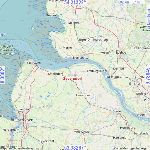
Geversdorf GPS coordinates[2]
53° 48' 0" North, 9° 4' 59.988" East
| Map corner | latitude | longitude |
|---|---|---|
| Upper-left | 54.21322°, | 8.3802° |
| Center: | 53.8°, | 9.08333° |
| Lower-right: | 53.38267°, | 9.78645° |
| Map W x H: | 92.3×92.3 km | = 57.4×57.4mi |
| max Lat: | 55.01917° ⇑10% North |
| Geversdorf: | 53.8° |
| min Lat: | ⇓90% South 47.40724° |
| min Long | Geversdorf | max Long |
| 5.92978° | 9.08333° | 14.98853° |
| W 35.8%⇐ | ⇒64.2% E |
Elevation
Elevation of Geversdorf is 0 m = 0 ft, and this is 249.1 m = 817 ft below average elevation for this country.
| Max E: |
1256 m = 4121 ft | 99.1% |
| Avg. | 249.1 m = 817 ft | |
| Geversdorf | 0 m = 0 ft | |
Min E: |
-5 m = -16 ft | 0.9% |
See also: Germany elevation on elevation.city.
Geographical zone
Geversdorf is located in North temperate zone (between Tropic of Cancer and the Arctic Circle). Distance of this North polar circle is 1419.2 km =881.8 mi to North.| Distance of | km | miles | from Geversdorf |
|---|---|---|---|
| North Pole | 4025.1 | 2501.1 | to North |
| Arctic Circle | 1419.2 | 881.8 | to North |
| Tropic Cancer | 3376.1 | 2097.8 | to South |
| Equator | 5982 | 3717 | to South |


Nearby cities:
15 places around Geversdorf: (largest is in red/bold)
• Balje
5 km =3.1 mi,  41°
41°
• Belum
5.8 km =3.6 mi,  288°
288°
• Brunsbüttel
10.7 km =6.6 mi,  7°
7°
• Bülkau
9.1 km =5.7 mi,  229°
229°
• Cadenberge
3.7 km =2.3 mi,  201°
201°
• Ihlienworth
13.2 km =8.2 mi,  235°
235°
• Krummendeich
8.6 km =5.3 mi,  66°
66°
• Neuenkirchen
12.7 km =7.9 mi,  258°
258°
• Neufeld
11.9 km =7.4 mi,  338°
338°
• Neuhaus an der Oste
3.3 km =2.1 mi,  270°
270°
• Oberndorf
7.1 km =4.4 mi,  141°
141°
• Oederquart
10.1 km =6.3 mi,  88°
88°
• Osterbruch
9.6 km =6 mi, 255°
• Otterndorf
12 km =7.5 mi, 274°
• Wingst
7.1 km =4.4 mi,  181°
181°
Sources, notices
• [Note1] Compared only with cities in Germany existing in our database
• [Src1] Map data: © OpenStreetMap contributors (CC-BY-SA)
• [Src2] Other city data from geonames.org with taken over terms of usage.
• [Src3] Geographical zone / Annual Mean Temperature by Robert A. Rohde @ Wikipedia
