Cadenberge geodata
Cadenberge (Lower Saxony) is a seat of a fourth-order administrative division; located in Germany in Europe/Berlin (GMT+2) time zone. With population of 3,421 people, there are 3674 cities with bigger population in this country. Compared to other cities in Germany, 89.6% of cities are located further ↓South; 64.6% of cities are located further →East and 94.8% of cities have higher elevation than Cadenberge. Note1


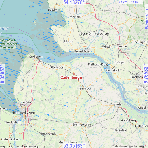
Cadenberge GPS coordinates[2]
53° 46' 9.336" North, 9° 3' 45.684" East
| Map corner | latitude | longitude |
|---|---|---|
| Upper-left | 54.18278°, | 8.35957° |
| Center: | 53.76926°, | 9.06269° |
| Lower-right: | 53.35163°, | 9.76582° |
| Map W x H: | 92.4×92.4 km | = 57.4×57.4mi |
| max Lat: | 55.01917° ⇑10.4% North |
| Cadenberge: | 53.76926° |
| min Lat: | ⇓89.6% South 47.40724° |
| min Long | Cadenberge | max Long |
| 5.92978° | 9.06269° | 14.98853° |
| W 35.4%⇐ | ⇒64.6% E |
Elevation
Elevation of Cadenberge is 9 m = 30 ft, and this is 240.1 m = 788 ft below average elevation for this country.
| Max E: |
1256 m = 4121 ft | 94.8% |
| Avg. | 249.1 m = 817 ft | |
| Cadenberge | 9 m = 30 ft | |
Min E: |
-5 m = -16 ft | 5.2% |
See also: Germany elevation on elevation.city.
Geographical zone
Cadenberge is located in North temperate zone (between Tropic of Cancer and the Arctic Circle). Distance of this North polar circle is 1422.6 km =884 mi to North.| Distance of | km | miles | from Cadenberge |
|---|---|---|---|
| North Pole | 4028.5 | 2503.2 | to North |
| Arctic Circle | 1422.6 | 884 | to North |
| Tropic Cancer | 3372.7 | 2095.7 | to South |
| Equator | 5978.6 | 3714.9 | to South |


Nearby cities:
15 places around Cadenberge: (largest is in red/bold)
• Balje
8.5 km =5.3 mi,  33°
33°
• Belum
6.7 km =4.2 mi,  322°
322°
• Bülkau
6.1 km =3.8 mi,  245°
245°
• Geversdorf
3.7 km =2.3 mi,  21°
21°
• Hemmoor
11 km =6.8 mi,  146°
146°
• Ihlienworth
10.4 km =6.5 mi, 247°
• Krummendeich
11.5 km =7.1 mi,  53°
53°
• Neuenkirchen
11.1 km =6.9 mi,  274°
274°
• Neuhaus an der Oste
4 km =2.5 mi,  331°
331°
• Oberndorf
6.1 km =3.8 mi,  110°
110°
• Odisheim
11.4 km =7.1 mi,  223°
223°
• Osten
11.9 km =7.4 mi,  130°
130°
• Osterbruch
8 km =5 mi,  276°
276°
• Otterndorf
11.5 km =7.1 mi,  292°
292°
• Wingst
3.9 km =2.4 mi,  162°
162°
Sources, notices
• [Note1] Compared only with cities in Germany existing in our database
• [Src1] Map data: © OpenStreetMap contributors (CC-BY-SA)
• [Src2] Other city data from geonames.org with taken over terms of usage.
• [Src3] Geographical zone / Annual Mean Temperature by Robert A. Rohde @ Wikipedia
