Bannewitz geodata
Bannewitz (Saxony) is a seat of a fourth-order administrative division; located in Germany in Europe/Berlin (GMT+2) time zone. With population of 10,851 people, there are 1521 cities with bigger population in this country. Compared to other cities in Germany, 58% of cities are located further ↓South; 96.9% of cities are located further ←West and 58.3% of cities have lower elevation than Bannewitz. Note1
Administrative division(s):
- Level 1: Saxony
- Level 3: Landkreis Sächsische Schweiz
- Level 4: Bannewitz


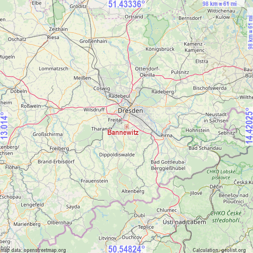
Bannewitz GPS coordinates[2]
50° 59' 34.476" North, 13° 43' 1.632" East
| Map corner | latitude | longitude |
|---|---|---|
| Upper-left | 51.43336°, | 13.014° |
| Center: | 50.99291°, | 13.71712° |
| Lower-right: | 50.54824°, | 14.42025° |
| Map W x H: | 98.4×98.4 km | = 61.1×61.1mi |
| max Lat: | 55.01917° ⇑42% North |
| Bannewitz: | 50.99291° |
| min Lat: | ⇓58% South 47.40724° |
| min Long | Bannewitz | max Long |
| 5.92978° | 13.71712° | 14.98853° |
| W 96.9%⇐ | ⇒3.1% E |
Elevation
Elevation of Bannewitz is 280 m = 919 ft, and this is 30.9 m = 101 ft above average elevation for this country.
| Max E: |
1256 m = 4121 ft | 41.7% |
| Bannewitz | 280 m 919 ft | |
| Avg. | 249.1 m = 817 ft | |
Min E: |
-5 m = -16 ft | 58.3% |
See also: Germany elevation on elevation.city.
Geographical zone
Bannewitz is located in North temperate zone (between Tropic of Cancer and the Arctic Circle). Distance of this North polar circle is 1731.3 km =1075.8 mi to North.| Distance of | km | miles | from Bannewitz |
|---|---|---|---|
| North Pole | 4337.2 | 2695 | to North |
| Arctic Circle | 1731.3 | 1075.8 | to North |
| Tropic Cancer | 3064 | 1903.9 | to South |
| Equator | 5669.9 | 3523.1 | to South |


Nearby cities:
15 places around Bannewitz: (largest is in red/bold)
• Albertstadt
10.6 km =6.6 mi,  19°
19°
• Dippoldiswalde
11.3 km =7 mi,  197°
197°
• Dohna
10.7 km =6.6 mi,  112°
112°
• Dorfhain
12.4 km =7.7 mi,  237°
237°
• Dresden
6.6 km =4.1 mi,  12°
12°
• Freital
4.9 km =3 mi,  281°
281°
• Heidenau
10.8 km =6.7 mi,  102°
102°
• Hermsdorf
7.8 km =4.8 mi,  170°
170°
• Kreischa
5.9 km =3.7 mi,  153°
153°
• Obercunnersdorf
13.9 km =8.6 mi,  232°
232°
• Rabenau
6.1 km =3.8 mi, 238°
• Radebeul
13.2 km =8.2 mi,  342°
342°
• Reinhardtsgrimma
11.5 km =7.1 mi, 166°
• Tharandt
9.6 km =6 mi,  264°
264°
• Wilsdruff
14.2 km =8.8 mi,  297°
297°
Sources, notices
• [Note1] Compared only with cities in Germany existing in our database
• [Src1] Map data: © OpenStreetMap contributors (CC-BY-SA)
• [Src2] Other city data from geonames.org with taken over terms of usage.
• [Src3] Geographical zone / Annual Mean Temperature by Robert A. Rohde @ Wikipedia
