Willingen geodata
Willingen (Hesse) is a populated place; located in Germany in Europe/Berlin (GMT+2) time zone. With population of 6,564 people, there are 2289 cities with bigger population in this country. Compared to other cities in Germany, 63.1% of cities are located further ↓South; 70% of cities are located further →East and 93.8% of cities have lower elevation than Willingen. Note1
Administrative division(s):
- Level 1: Hesse
- Level 2: Regierungsbezirk Kassel
- Level 3: Landkreis Waldeck-Frankenberg
- Level 4: Willingen (Upland)


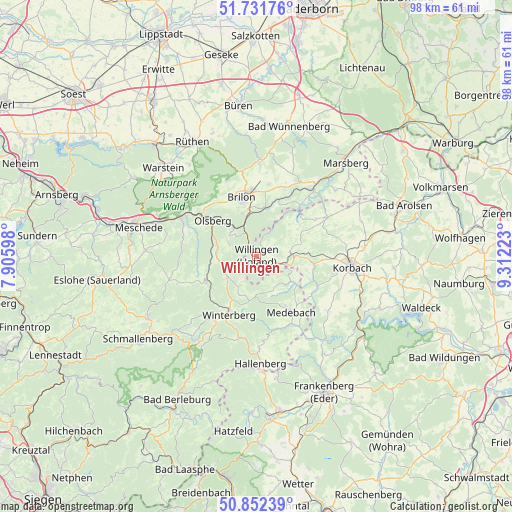
Willingen GPS coordinates[2]
51° 17' 39.048" North, 8° 36' 32.76" East
| Map corner | latitude | longitude |
|---|---|---|
| Upper-left | 51.73176°, | 7.90598° |
| Center: | 51.29418°, | 8.6091° |
| Lower-right: | 50.85239°, | 9.31223° |
| Map W x H: | 97.8×97.8 km | = 60.8×60.8mi |
| max Lat: | 55.01917° ⇑36.9% North |
| Willingen: | 51.29418° |
| min Lat: | ⇓63.1% South 47.40724° |
| min Long | Willingen | max Long |
| 5.92978° | 8.6091° | 14.98853° |
| W 30%⇐ | ⇒70% E |
Elevation
Elevation of Willingen is 571 m = 1873 ft, and this is 321.9 m = 1056 ft above average elevation for this country.
| Max E: |
1256 m = 4121 ft | 6.2% |
| Willingen | 571 m 1873 ft | |
| Avg. | 249.1 m = 817 ft | |
Min E: |
-5 m = -16 ft | 93.8% |
See also: Germany elevation on elevation.city.
Geographical zone
Willingen is located in North temperate zone (between Tropic of Cancer and the Arctic Circle). Distance of this North polar circle is 1697.8 km =1055 mi to North.| Distance of | km | miles | from Willingen |
|---|---|---|---|
| North Pole | 4303.7 | 2674.2 | to North |
| Arctic Circle | 1697.8 | 1055 | to North |
| Tropic Cancer | 3097.5 | 1924.7 | to South |
| Equator | 5703.4 | 3543.9 | to South |


Nearby cities:
15 places around Willingen: (largest is in red/bold)
• Altenbüren
12.5 km =7.8 mi,  325°
325°
• Bad Fredeburg
23.9 km =14.9 mi,  240°
240°
• Bestwig
16.3 km =10.1 mi,  297°
297°
• Brilon
11.5 km =7.1 mi,  346°
346°
• Bromskirchen
22.3 km =13.9 mi,  176°
176°
• Hallenberg
20.4 km =12.7 mi, 177°
• Korbach
18.5 km =11.5 mi,  96°
96°
• Marsberg
25 km =15.5 mi,  41°
41°
• Medebach
12.7 km =7.9 mi,  147°
147°
• Meschede
23.5 km =14.6 mi,  285°
285°
• Olsberg
10.8 km =6.7 mi,  309°
309°
• Rüthen
25 km =15.5 mi, 331°
• Silbach
11.4 km =7.1 mi,  230°
230°
• Warstein
24.7 km =15.3 mi, 312°
• Winterberg
12.4 km =7.7 mi,  204°
204°
Sources, notices
• [Note1] Compared only with cities in Germany existing in our database
• [Src1] Map data: © OpenStreetMap contributors (CC-BY-SA)
• [Src2] Other city data from geonames.org with taken over terms of usage.
• [Src3] Geographical zone / Annual Mean Temperature by Robert A. Rohde @ Wikipedia
