Marsberg geodata
Marsberg (North Rhine-Westphalia) is a populated place; located in Germany in Europe/Berlin (GMT+2) time zone. With population of 21,914 people, there are 686 cities with bigger population in this country. Compared to other cities in Germany, 65.7% of cities are located further ↓South; 67.3% of cities are located further →East and 54.3% of cities have lower elevation than Marsberg. Note1
Administrative division(s):
- Level 1: North Rhine-Westphalia
- Level 2: Regierungsbezirk Arnsberg
- Level 3: Hochsauerlandkreis
- Level 4: Marsberg


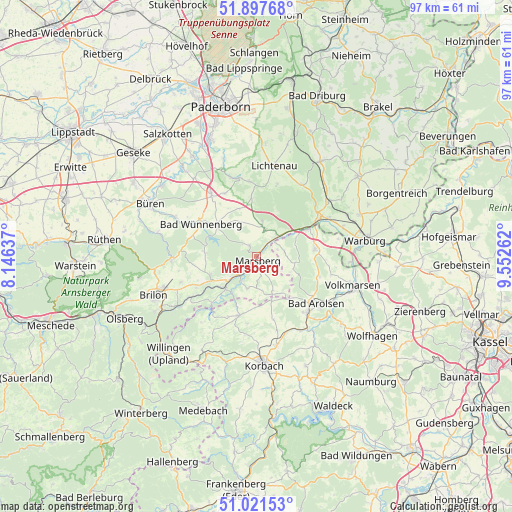
Marsberg GPS coordinates[2]
51° 27' 42.156" North, 8° 50' 58.164" East
| Map corner | latitude | longitude |
|---|---|---|
| Upper-left | 51.89768°, | 8.14637° |
| Center: | 51.46171°, | 8.84949° |
| Lower-right: | 51.02153°, | 9.55262° |
| Map W x H: | 97.4×97.4 km | = 60.5×60.5mi |
| max Lat: | 55.01917° ⇑34.3% North |
| Marsberg: | 51.46171° |
| min Lat: | ⇓65.7% South 47.40724° |
| min Long | Marsberg | max Long |
| 5.92978° | 8.84949° | 14.98853° |
| W 32.7%⇐ | ⇒67.3% E |
Elevation
Elevation of Marsberg is 254 m = 833 ft, and this is 4.9 m = 16 ft above average elevation for this country.
| Max E: |
1256 m = 4121 ft | 45.7% |
| Marsberg | 254 m 833 ft | |
| Avg. | 249.1 m = 817 ft | |
Min E: |
-5 m = -16 ft | 54.3% |
See also: Germany elevation on elevation.city.
Geographical zone
Marsberg is located in North temperate zone (between Tropic of Cancer and the Arctic Circle). Distance of this North polar circle is 1679.2 km =1043.4 mi to North.| Distance of | km | miles | from Marsberg |
|---|---|---|---|
| North Pole | 4285.1 | 2662.6 | to North |
| Arctic Circle | 1679.2 | 1043.4 | to North |
| Tropic Cancer | 3116.1 | 1936.3 | to South |
| Equator | 5722 | 3555.5 | to South |


Nearby cities:
15 places around Marsberg: (largest is in red/bold)
• Altenbüren
25.3 km =15.7 mi,  250°
250°
• Bad Arolsen
14.6 km =9.1 mi,  128°
128°
• Breuna
23.8 km =14.8 mi,  102°
102°
• Brilon
20.7 km =12.9 mi, 248°
• Büren
22.4 km =13.9 mi,  296°
296°
• Korbach
20.8 km =12.9 mi,  175°
175°
• Lichtenau
17.6 km =10.9 mi,  10°
10°
• Rhoden
11.3 km =7 mi,  83°
83°
• Sachsenhausen
26.7 km =16.6 mi,  155°
155°
• Volkmarsen
19.5 km =12.1 mi,  107°
107°
• Warburg
20.8 km =12.9 mi, 81°
• Willebadessen
22.4 km =13.9 mi,  35°
35°
• Willingen
25 km =15.5 mi,  221°
221°
• Wolfhagen
26.9 km =16.7 mi,  124°
124°
• Wünnenberg
12.3 km =7.6 mi, 301°
Sources, notices
• [Note1] Compared only with cities in Germany existing in our database
• [Src1] Map data: © OpenStreetMap contributors (CC-BY-SA)
• [Src2] Other city data from geonames.org with taken over terms of usage.
• [Src3] Geographical zone / Annual Mean Temperature by Robert A. Rohde @ Wikipedia
