Bad Fredeburg geodata
Bad Fredeburg (North Rhine-Westphalia) is a populated place; located in Germany in Europe/Berlin (GMT+2) time zone. With population of 3,995 people, there are 3304 cities with bigger population in this country. Compared to other cities in Germany, 61.4% of cities are located further ↓South; 72.8% of cities are located further →East and 83.8% of cities have lower elevation than Bad Fredeburg. Note1
Administrative division(s):
- Level 1: North Rhine-Westphalia
- Level 2: Regierungsbezirk Arnsberg
- Level 3: Hochsauerlandkreis
- Level 4: Schmallenberg


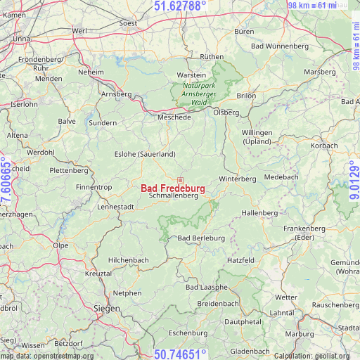
Bad Fredeburg GPS coordinates[2]
51° 11' 21.48" North, 8° 18' 35.208" East
| Map corner | latitude | longitude |
|---|---|---|
| Upper-left | 51.62788°, | 7.60665° |
| Center: | 51.1893°, | 8.30978° |
| Lower-right: | 50.74651°, | 9.0129° |
| Map W x H: | 98×98 km | = 60.9×60.9mi |
| max Lat: | 55.01917° ⇑38.6% North |
| Bad Fredeburg: | 51.1893° |
| min Lat: | ⇓61.4% South 47.40724° |
| min Long | Bad Fredeburg | max Long |
| 5.92978° | 8.30978° | 14.98853° |
| W 27.2%⇐ | ⇒72.8% E |
Elevation
Elevation of Bad Fredeburg is 460 m = 1509 ft, and this is 210.9 m = 692 ft above average elevation for this country.
| Max E: |
1256 m = 4121 ft | 16.2% |
| Bad Fredeburg | 460 m 1509 ft | |
| Avg. | 249.1 m = 817 ft | |
Min E: |
-5 m = -16 ft | 83.8% |
See also: Germany elevation on elevation.city.
Geographical zone
Bad Fredeburg is located in North temperate zone (between Tropic of Cancer and the Arctic Circle). Distance of this North polar circle is 1709.5 km =1062.2 mi to North.| Distance of | km | miles | from Bad Fredeburg |
|---|---|---|---|
| North Pole | 4315.3 | 2681.4 | to North |
| Arctic Circle | 1709.5 | 1062.2 | to North |
| Tropic Cancer | 3085.8 | 1917.4 | to South |
| Equator | 5691.7 | 3536.7 | to South |


Nearby cities:
15 places around Bad Fredeburg: (largest is in red/bold)
• Bad Berleburg
16.3 km =10.1 mi,  159°
159°
• Bamenohl
22.9 km =14.2 mi,  263°
263°
• Bestwig
20.1 km =12.5 mi,  18°
18°
• Erndtebrück
22.6 km =14 mi,  190°
190°
• Eslohe
12.1 km =7.5 mi,  306°
306°
• Finnentrop
23.6 km =14.7 mi, 264°
• Hallenberg
23.3 km =14.5 mi,  111°
111°
• Kirchhundem
19.2 km =11.9 mi,  233°
233°
• Lennestadt
18.7 km =11.6 mi,  244°
244°
• Meschede
18 km =11.2 mi,  354°
354°
• Olsberg
22.3 km =13.9 mi,  33°
33°
• Schmallenberg
4.2 km =2.6 mi,  204°
204°
• Silbach
12.9 km =8 mi,  69°
69°
• Willingen
23.9 km =14.9 mi,  60°
60°
• Winterberg
15.7 km =9.8 mi,  88°
88°
Sources, notices
• [Note1] Compared only with cities in Germany existing in our database
• [Src1] Map data: © OpenStreetMap contributors (CC-BY-SA)
• [Src2] Other city data from geonames.org with taken over terms of usage.
• [Src3] Geographical zone / Annual Mean Temperature by Robert A. Rohde @ Wikipedia
