Olsberg geodata
Olsberg (North Rhine-Westphalia) is a populated place; located in Germany in Europe/Berlin (GMT+2) time zone. With population of 15,814 people, there are 1014 cities with bigger population in this country. Compared to other cities in Germany, 64.1% of cities are located further ↓South; 71.2% of cities are located further →East and 67.4% of cities have lower elevation than Olsberg. Note1
Administrative division(s):
- Level 1: North Rhine-Westphalia
- Level 2: Regierungsbezirk Arnsberg
- Level 3: Hochsauerlandkreis
- Level 4: Olsberg


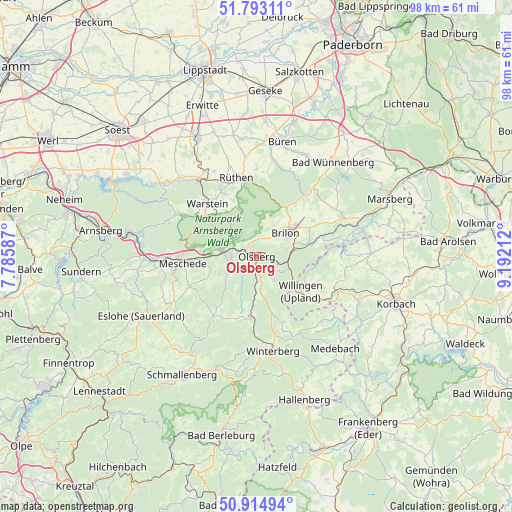
Olsberg GPS coordinates[2]
51° 21' 22.068" North, 8° 29' 20.364" East
| Map corner | latitude | longitude |
|---|---|---|
| Upper-left | 51.79311°, | 7.78587° |
| Center: | 51.35613°, | 8.48899° |
| Lower-right: | 50.91494°, | 9.19212° |
| Map W x H: | 97.6×97.6 km | = 60.6×60.6mi |
| max Lat: | 55.01917° ⇑35.9% North |
| Olsberg: | 51.35613° |
| min Lat: | ⇓64.1% South 47.40724° |
| min Long | Olsberg | max Long |
| 5.92978° | 8.48899° | 14.98853° |
| W 28.8%⇐ | ⇒71.2% E |
Elevation
Elevation of Olsberg is 338 m = 1109 ft, and this is 88.9 m = 292 ft above average elevation for this country.
| Max E: |
1256 m = 4121 ft | 32.6% |
| Olsberg | 338 m 1109 ft | |
| Avg. | 249.1 m = 817 ft | |
Min E: |
-5 m = -16 ft | 67.4% |
See also: Germany elevation on elevation.city.
Geographical zone
Olsberg is located in North temperate zone (between Tropic of Cancer and the Arctic Circle). Distance of this North polar circle is 1690.9 km =1050.7 mi to North.| Distance of | km | miles | from Olsberg |
|---|---|---|---|
| North Pole | 4296.8 | 2669.9 | to North |
| Arctic Circle | 1690.9 | 1050.7 | to North |
| Tropic Cancer | 3104.3 | 1928.9 | to South |
| Equator | 5710.3 | 3548.2 | to South |


Nearby cities:
15 places around Olsberg: (largest is in red/bold)
• Altenbüren
3.6 km =2.2 mi,  19°
19°
• Anröchte
25.8 km =16 mi,  335°
335°
• Bad Fredeburg
22.3 km =13.9 mi,  213°
213°
• Bestwig
6.1 km =3.8 mi,  274°
274°
• Brilon
7.1 km =4.4 mi,  53°
53°
• Büren
22.2 km =13.8 mi,  12°
12°
• Eslohe
25 km =15.5 mi,  242°
242°
• Medebach
23.3 km =14.5 mi,  139°
139°
• Meschede
14.3 km =8.9 mi, 267°
• Rüthen
15.4 km =9.6 mi,  346°
346°
• Silbach
14.1 km =8.8 mi,  181°
181°
• Warstein
13.9 km =8.6 mi,  315°
315°
• Willingen
10.8 km =6.7 mi,  129°
129°
• Winterberg
18.5 km =11.5 mi,  170°
170°
• Wünnenberg
23.3 km =14.5 mi,  38°
38°
Sources, notices
• [Note1] Compared only with cities in Germany existing in our database
• [Src1] Map data: © OpenStreetMap contributors (CC-BY-SA)
• [Src2] Other city data from geonames.org with taken over terms of usage.
• [Src3] Geographical zone / Annual Mean Temperature by Robert A. Rohde @ Wikipedia
