Lübars geodata
Lübars (Berlin) is a section of populated place; located in Germany in Europe/Berlin (GMT+2) time zone. With population of 4,817 people, there are 2894 cities with bigger population in this country. Compared to other cities in Germany, 78.9% of cities are located further ↓South; 94.7% of cities are located further ←West and 77.9% of cities have higher elevation than Lübars. Note1


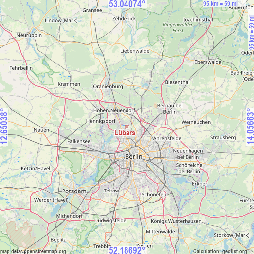
Lübars GPS coordinates[2]
52° 36' 57.276" North, 13° 21' 12.6" East
| Map corner | latitude | longitude |
|---|---|---|
| Upper-left | 53.04074°, | 12.65038° |
| Center: | 52.61591°, | 13.3535° |
| Lower-right: | 52.18692°, | 14.05663° |
| Map W x H: | 94.9×94.9 km | = 59×59mi |
| max Lat: | 55.01917° ⇑21.1% North |
| Lübars: | 52.61591° |
| min Lat: | ⇓78.9% South 47.40724° |
| min Long | Lübars | max Long |
| 5.92978° | 13.3535° | 14.98853° |
| W 94.7%⇐ | ⇒5.3% E |
Elevation
Elevation of Lübars is 53 m = 174 ft, and this is 196.1 m = 643 ft below average elevation for this country.
| Max E: |
1256 m = 4121 ft | 77.9% |
| Avg. | 249.1 m = 817 ft | |
| Lübars | 53 m = 174 ft | |
Min E: |
-5 m = -16 ft | 22.1% |
See also: Germany elevation on elevation.city.
Geographical zone
Lübars is located in North temperate zone (between Tropic of Cancer and the Arctic Circle). Distance of this North polar circle is 1550.8 km =963.6 mi to North.| Distance of | km | miles | from Lübars |
|---|---|---|---|
| North Pole | 4156.7 | 2582.9 | to North |
| Arctic Circle | 1550.8 | 963.6 | to North |
| Tropic Cancer | 3244.4 | 2016 | to South |
| Equator | 5850.3 | 3635.2 | to South |


Nearby cities:
15 places around Lübars: (largest is in red/bold)
• Blankenburg
7.3 km =4.5 mi,  110°
110°
• Blankenfelde
2.5 km =1.6 mi,  83°
83°
• Französisch Buchholz
5.4 km =3.4 mi, 106°
• Frohnau
4.7 km =2.9 mi,  294°
294°
• Glienicke
2.7 km =1.7 mi,  316°
316°
• Hermsdorf
3.2 km =2 mi,  266°
266°
• Märkisches Viertel
2 km =1.2 mi,  171°
171°
• Niederschönhausen
4.8 km =3 mi,  136°
136°
• Pankow
6.1 km =3.8 mi,  147°
147°
• Reinickendorf
5.6 km =3.5 mi,  193°
193°
• Rosenthal
2.4 km =1.5 mi, 137°
• Tegel
6 km =3.7 mi,  222°
222°
• Waidmannslust
2.5 km =1.6 mi,  246°
246°
• Wilhelmsruh
3.4 km =2.1 mi,  162°
162°
• Wittenau
3.3 km =2.1 mi, 220°
Sources, notices
• [Note1] Compared only with cities in Germany existing in our database
• [Src1] Map data: © OpenStreetMap contributors (CC-BY-SA)
• [Src2] Other city data from geonames.org with taken over terms of usage.
• [Src3] Geographical zone / Annual Mean Temperature by Robert A. Rohde @ Wikipedia
