Waidmannslust geodata
Waidmannslust (Berlin) is a section of populated place; located in Germany in Europe/Berlin (GMT+2) time zone. With population of 9,715 people, there are 1667 cities with bigger population in this country. Compared to other cities in Germany, 78.8% of cities are located further ↓South; 94.5% of cities are located further ←West and 79.9% of cities have higher elevation than Waidmannslust. Note1


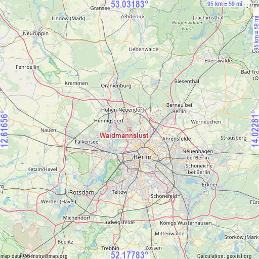
Waidmannslust GPS coordinates[2]
52° 36' 24.876" North, 13° 19' 10.848" East
| Map corner | latitude | longitude |
|---|---|---|
| Upper-left | 53.03183°, | 12.61656° |
| Center: | 52.60691°, | 13.31968° |
| Lower-right: | 52.17783°, | 14.02281° |
| Map W x H: | 95×95 km | = 59×59mi |
| max Lat: | 55.01917° ⇑21.2% North |
| Waidmannslust: | 52.60691° |
| min Lat: | ⇓78.8% South 47.40724° |
| min Long | Waidmannslust | max Long |
| 5.92978° | 13.31968° | 14.98853° |
| W 94.5%⇐ | ⇒5.5% E |
Elevation
Elevation of Waidmannslust is 47 m = 154 ft, and this is 202.1 m = 663 ft below average elevation for this country.
| Max E: |
1256 m = 4121 ft | 79.9% |
| Avg. | 249.1 m = 817 ft | |
| Waidmannslust | 47 m = 154 ft | |
Min E: |
-5 m = -16 ft | 20.1% |
See also: Germany elevation on elevation.city.
Geographical zone
Waidmannslust is located in North temperate zone (between Tropic of Cancer and the Arctic Circle). Distance of this North polar circle is 1551.8 km =964.2 mi to North.| Distance of | km | miles | from Waidmannslust |
|---|---|---|---|
| North Pole | 4157.7 | 2583.5 | to North |
| Arctic Circle | 1551.8 | 964.2 | to North |
| Tropic Cancer | 3243.4 | 2015.4 | to South |
| Equator | 5849.3 | 3634.6 | to South |


Nearby cities:
15 places around Waidmannslust: (largest is in red/bold)
• Blankenfelde
5 km =3.1 mi,  74°
74°
• Frohnau
3.5 km =2.2 mi,  325°
325°
• Glienicke
3 km =1.9 mi,  7°
7°
• Heiligensee
5.1 km =3.2 mi,  279°
279°
• Hermsdorf
1.2 km =0.7 mi,  311°
311°
• Konradshöhe
6.7 km =4.2 mi,  248°
248°
• Lübars
2.5 km =1.6 mi, 66°
• Märkisches Viertel
2.7 km =1.7 mi,  110°
110°
• Niederschönhausen
6.1 km =3.8 mi, 113°
• Pankow
7 km =4.3 mi,  127°
127°
• Reinickendorf
4.6 km =2.9 mi,  168°
168°
• Rosenthal
4 km =2.5 mi,  101°
101°
• Tegel
3.9 km =2.4 mi,  206°
206°
• Wilhelmsruh
4 km =2.5 mi,  123°
123°
• Wittenau
1.5 km =0.9 mi,  175°
175°
Sources, notices
• [Note1] Compared only with cities in Germany existing in our database
• [Src1] Map data: © OpenStreetMap contributors (CC-BY-SA)
• [Src2] Other city data from geonames.org with taken over terms of usage.
• [Src3] Geographical zone / Annual Mean Temperature by Robert A. Rohde @ Wikipedia
