Hermsdorf geodata
Hermsdorf (Berlin) is a section of populated place; located in Germany in Europe/Berlin (GMT+2) time zone. With population of 16,113 people, there are 992 cities with bigger population in this country. Compared to other cities in Germany, 78.9% of cities are located further ↓South; 94.4% of cities are located further ←West and 84.5% of cities have higher elevation than Hermsdorf. Note1


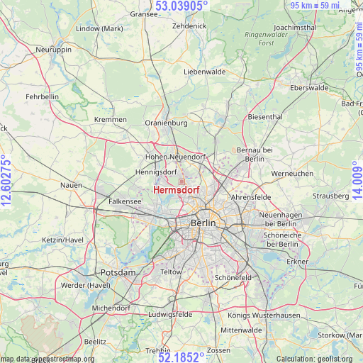
Hermsdorf GPS coordinates[2]
52° 36' 51.156" North, 13° 18' 21.132" East
| Map corner | latitude | longitude |
|---|---|---|
| Upper-left | 53.03905°, | 12.60275° |
| Center: | 52.61421°, | 13.30587° |
| Lower-right: | 52.1852°, | 14.009° |
| Map W x H: | 94.9×94.9 km | = 59×59mi |
| max Lat: | 55.01917° ⇑21.1% North |
| Hermsdorf: | 52.61421° |
| min Lat: | ⇓78.9% South 47.40724° |
| min Long | Hermsdorf | max Long |
| 5.92978° | 13.30587° | 14.98853° |
| W 94.4%⇐ | ⇒5.6% E |
Elevation
Elevation of Hermsdorf is 36 m = 118 ft, and this is 213.1 m = 699 ft below average elevation for this country.
| Max E: |
1256 m = 4121 ft | 84.5% |
| Avg. | 249.1 m = 817 ft | |
| Hermsdorf | 36 m = 118 ft | |
Min E: |
-5 m = -16 ft | 15.5% |
See also: Germany elevation on elevation.city.
Geographical zone
Hermsdorf is located in North temperate zone (between Tropic of Cancer and the Arctic Circle). Distance of this North polar circle is 1551 km =963.7 mi to North.| Distance of | km | miles | from Hermsdorf |
|---|---|---|---|
| North Pole | 4156.9 | 2583 | to North |
| Arctic Circle | 1551 | 963.7 | to North |
| Tropic Cancer | 3244.2 | 2015.9 | to South |
| Equator | 5850.2 | 3635.1 | to South |


Nearby cities:
15 places around Hermsdorf: (largest is in red/bold)
• Blankenfelde
5.7 km =3.5 mi,  85°
85°
• Frohnau
2.4 km =1.5 mi,  333°
333°
• Glienicke
2.5 km =1.6 mi,  31°
31°
• Heiligensee
4.1 km =2.5 mi,  270°
270°
• Hohen Neuendorf
7.2 km =4.5 mi,  344°
344°
• Konradshöhe
6.2 km =3.9 mi,  238°
238°
• Lübars
3.2 km =2 mi, 86°
• Märkisches Viertel
3.9 km =2.4 mi,  116°
116°
• Niederschönhausen
7.3 km =4.5 mi, 116°
• Reinickendorf
5.6 km =3.5 mi,  160°
160°
• Rosenthal
5.1 km =3.2 mi,  108°
108°
• Tegel
4.3 km =2.7 mi,  190°
190°
• Waidmannslust
1.2 km =0.7 mi,  131°
131°
• Wilhelmsruh
5.2 km =3.2 mi, 125°
• Wittenau
2.6 km =1.6 mi, 156°
Sources, notices
• [Note1] Compared only with cities in Germany existing in our database
• [Src1] Map data: © OpenStreetMap contributors (CC-BY-SA)
• [Src2] Other city data from geonames.org with taken over terms of usage.
• [Src3] Geographical zone / Annual Mean Temperature by Robert A. Rohde @ Wikipedia
