Wilburgstetten geodata
Wilburgstetten (Bavaria) is a seat of a fourth-order administrative division; located in Germany in Europe/Berlin (GMT+2) time zone. With population of 2,183 people, there are 4830 cities with bigger population in this country. Compared to other cities in Germany, 82.8% of cities are located further ↑North; 57% of cities are located further ←West and 81.7% of cities have lower elevation than Wilburgstetten. Note1
Administrative division(s):
- Level 1: Bavaria
- Level 2: Regierungsbezirk Mittelfranken
- Level 3: Landkreis Ansbach
- Level 4: Wilburgstetten


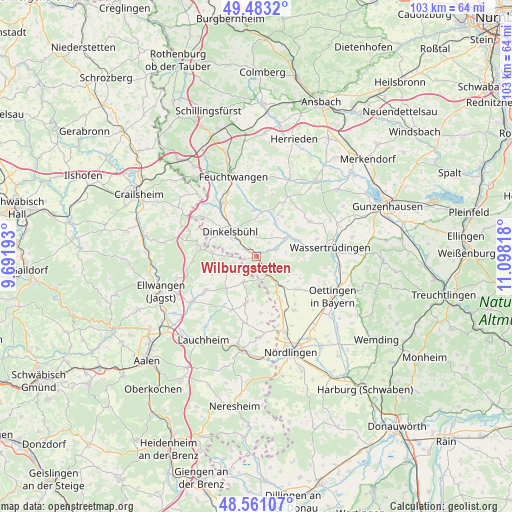
Wilburgstetten GPS coordinates[2]
49° 1' 27.372" North, 10° 23' 42.18" East
| Map corner | latitude | longitude |
|---|---|---|
| Upper-left | 49.4832°, | 9.69193° |
| Center: | 49.02427°, | 10.39505° |
| Lower-right: | 48.56107°, | 11.09818° |
| Map W x H: | 102.5×102.5 km | = 63.7×63.7mi |
| max Lat: | 55.01917° ⇑82.8% North |
| Wilburgstetten: | 49.02427° |
| min Lat: | ⇓17.2% South 47.40724° |
| min Long | Wilburgstetten | max Long |
| 5.92978° | 10.39505° | 14.98853° |
| W 57%⇐ | ⇒43% E |
Elevation
Elevation of Wilburgstetten is 444 m = 1457 ft, and this is 194.9 m = 639 ft above average elevation for this country.
| Max E: |
1256 m = 4121 ft | 18.3% |
| Wilburgstetten | 444 m 1457 ft | |
| Avg. | 249.1 m = 817 ft | |
Min E: |
-5 m = -16 ft | 81.7% |
See also: Germany elevation on elevation.city.
Geographical zone
Wilburgstetten is located in North temperate zone (between Tropic of Cancer and the Arctic Circle). Distance of this North polar circle is 1950.2 km =1211.8 mi to North.| Distance of | km | miles | from Wilburgstetten |
|---|---|---|---|
| North Pole | 4556.1 | 2831 | to North |
| Arctic Circle | 1950.2 | 1211.8 | to North |
| Tropic Cancer | 2845.1 | 1767.9 | to South |
| Equator | 5451 | 3387.1 | to South |


Nearby cities:
15 places around Wilburgstetten: (largest is in red/bold)
• Dinkelsbühl
7.4 km =4.6 mi,  312°
312°
• Dürrwangen
9.3 km =5.8 mi,  355°
355°
• Fremdingen
7.4 km =4.6 mi,  141°
141°
• Gerolfingen
9.1 km =5.7 mi,  69°
69°
• Langfurth
9.6 km =6 mi,  26°
26°
• Marktoffingen
12.3 km =7.6 mi,  153°
153°
• Mönchsroth
2.7 km =1.7 mi,  256°
256°
• Röckingen
12.5 km =7.8 mi, 73°
• Schopfloch
12.3 km =7.6 mi,  328°
328°
• Stödtlen
7.4 km =4.6 mi,  248°
248°
• Tannhausen
5.6 km =3.5 mi,  205°
205°
• Unterschneidheim
10.3 km =6.4 mi,  191°
191°
• Weiltingen
4.4 km =2.7 mi, 68°
• Wittelshofen
7.5 km =4.7 mi,  56°
56°
• Wört
9 km =5.6 mi,  274°
274°
Sources, notices
• [Note1] Compared only with cities in Germany existing in our database
• [Src1] Map data: © OpenStreetMap contributors (CC-BY-SA)
• [Src2] Other city data from geonames.org with taken over terms of usage.
• [Src3] Geographical zone / Annual Mean Temperature by Robert A. Rohde @ Wikipedia
