Dinkelsbühl geodata
Dinkelsbühl (Bavaria) is a populated place; located in Germany in Europe/Berlin (GMT+2) time zone. With population of 11,724 people, there are 1400 cities with bigger population in this country. Compared to other cities in Germany, 82.1% of cities are located further ↑North; 55.8% of cities are located further ←West and 82.1% of cities have lower elevation than Dinkelsbühl. Note1
Administrative division(s):
- Level 1: Bavaria
- Level 2: Regierungsbezirk Mittelfranken
- Level 3: Landkreis Ansbach
- Level 4: Dinkelsbühl


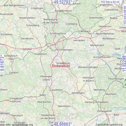
Dinkelsbühl GPS coordinates[2]
49° 4' 9.912" North, 10° 19' 11.46" East
| Map corner | latitude | longitude |
|---|---|---|
| Upper-left | 49.52793°, | 9.61673° |
| Center: | 49.06942°, | 10.31985° |
| Lower-right: | 48.60663°, | 11.02298° |
| Map W x H: | 102.4×102.4 km | = 63.6×63.6mi |
| max Lat: | 55.01917° ⇑82.1% North |
| Dinkelsbühl: | 49.06942° |
| min Lat: | ⇓17.9% South 47.40724° |
| min Long | Dinkelsbühl | max Long |
| 5.92978° | 10.31985° | 14.98853° |
| W 55.8%⇐ | ⇒44.2% E |
Elevation
Elevation of Dinkelsbühl is 447 m = 1467 ft, and this is 197.9 m = 649 ft above average elevation for this country.
| Max E: |
1256 m = 4121 ft | 17.9% |
| Dinkelsbühl | 447 m 1467 ft | |
| Avg. | 249.1 m = 817 ft | |
Min E: |
-5 m = -16 ft | 82.1% |
See also: Germany elevation on elevation.city.
Geographical zone
Dinkelsbühl is located in North temperate zone (between Tropic of Cancer and the Arctic Circle). Distance of this North polar circle is 1945.2 km =1208.7 mi to North.| Distance of | km | miles | from Dinkelsbühl |
|---|---|---|---|
| North Pole | 4551.1 | 2827.9 | to North |
| Arctic Circle | 1945.2 | 1208.7 | to North |
| Tropic Cancer | 2850.1 | 1771 | to South |
| Equator | 5456 | 3390.2 | to South |


Nearby cities:
15 places around Dinkelsbühl: (largest is in red/bold)
• Burk
13.6 km =8.5 mi,  58°
58°
• Dentlein am Forst
11.5 km =7.1 mi,  40°
40°
• Dürrwangen
6.4 km =4 mi,  48°
48°
• Ellenberg
9.5 km =5.9 mi,  232°
232°
• Feuchtwangen
10.5 km =6.5 mi,  7°
7°
• Langfurth
10.4 km =6.5 mi,  70°
70°
• Lichtenau
10.9 km =6.8 mi,  23°
23°
• Mönchsroth
6.3 km =3.9 mi,  153°
153°
• Schopfloch
5.6 km =3.5 mi,  350°
350°
• Stödtlen
7.9 km =4.9 mi,  190°
190°
• Tannhausen
10.5 km =6.5 mi,  163°
163°
• Weiltingen
10.1 km =6.3 mi,  109°
109°
• Wilburgstetten
7.4 km =4.6 mi,  132°
132°
• Wittelshofen
11.8 km =7.3 mi,  94°
94°
• Wört
5.5 km =3.4 mi,  218°
218°
Sources, notices
• [Note1] Compared only with cities in Germany existing in our database
• [Src1] Map data: © OpenStreetMap contributors (CC-BY-SA)
• [Src2] Other city data from geonames.org with taken over terms of usage.
• [Src3] Geographical zone / Annual Mean Temperature by Robert A. Rohde @ Wikipedia
