Werther geodata
Werther (North Rhine-Westphalia) is a populated place; located in Germany in Europe/Berlin (GMT+2) time zone. With population of 11,575 people, there are 1419 cities with bigger population in this country. Compared to other cities in Germany, 72.8% of cities are located further ↓South; 71.8% of cities are located further →East and 63.5% of cities have higher elevation than Werther. Note1
Administrative division(s):
- Level 1: North Rhine-Westphalia
- Level 2: Regierungsbezirk Detmold
- Level 3: Kreis Gütersloh
- Level 4: Werther (Westf.)


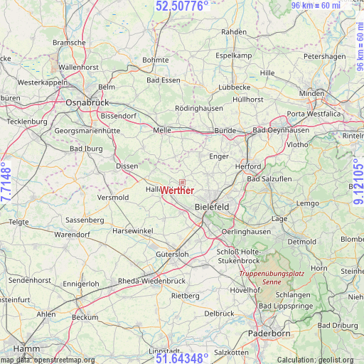
Werther GPS coordinates[2]
52° 4' 39.756" North, 8° 25' 4.548" East
| Map corner | latitude | longitude |
|---|---|---|
| Upper-left | 52.50776°, | 7.7148° |
| Center: | 52.07771°, | 8.41793° |
| Lower-right: | 51.64348°, | 9.12105° |
| Map W x H: | 96.1×96.1 km | = 59.7×59.7mi |
| max Lat: | 55.01917° ⇑27.2% North |
| Werther: | 52.07771° |
| min Lat: | ⇓72.8% South 47.40724° |
| min Long | Werther | max Long |
| 5.92978° | 8.41793° | 14.98853° |
| W 28.2%⇐ | ⇒71.8% E |
Elevation
Elevation of Werther is 129 m = 423 ft, and this is 120.1 m = 394 ft below average elevation for this country.
| Max E: |
1256 m = 4121 ft | 63.5% |
| Avg. | 249.1 m = 817 ft | |
| Werther | 129 m = 423 ft | |
Min E: |
-5 m = -16 ft | 36.5% |
See also: Germany elevation on elevation.city.
Geographical zone
Werther is located in North temperate zone (between Tropic of Cancer and the Arctic Circle). Distance of this North polar circle is 1610.7 km =1000.8 mi to North.| Distance of | km | miles | from Werther |
|---|---|---|---|
| North Pole | 4216.6 | 2620.1 | to North |
| Arctic Circle | 1610.7 | 1000.8 | to North |
| Tropic Cancer | 3184.6 | 1978.8 | to South |
| Equator | 5790.5 | 3598 | to South |


Nearby cities:
15 places around Werther: (largest is in red/bold)
• Bad Rothenfelde
17.7 km =11 mi,  284°
284°
• Bielefeld
9.3 km =5.8 mi,  122°
122°
• Borgholzhausen
8.4 km =5.2 mi,  289°
289°
• Bünde
17.7 km =11 mi,  40°
40°
• Dissen
15.5 km =9.6 mi, 285°
• Enger
11.8 km =7.3 mi,  53°
53°
• Halle
4.4 km =2.7 mi,  243°
243°
• Harsewinkel
18.3 km =11.4 mi,  225°
225°
• Herford
17.9 km =11.1 mi,  76°
76°
• Hiddenhausen
16.8 km =10.4 mi, 53°
• Melle
14.8 km =9.2 mi,  338°
338°
• Neuenkirchen
7 km =4.3 mi, 343°
• Spenge
8.3 km =5.2 mi,  33°
33°
• Steinhagen
8.7 km =5.4 mi,  188°
188°
• Versmold
18.6 km =11.6 mi,  257°
257°
Sources, notices
• [Note1] Compared only with cities in Germany existing in our database
• [Src1] Map data: © OpenStreetMap contributors (CC-BY-SA)
• [Src2] Other city data from geonames.org with taken over terms of usage.
• [Src3] Geographical zone / Annual Mean Temperature by Robert A. Rohde @ Wikipedia
