Halle geodata
Halle (North Rhine-Westphalia) is a populated place; located in Germany in Europe/Berlin (GMT+2) time zone. With population of 21,071 people, there are 723 cities with bigger population in this country. Compared to other cities in Germany, 72.6% of cities are located further ↓South; 72.3% of cities are located further →East and 63.5% of cities have higher elevation than Halle. Note1
Administrative division(s):
- Level 1: North Rhine-Westphalia
- Level 2: Regierungsbezirk Detmold
- Level 3: Kreis Gütersloh
- Level 4: Halle (Westf.)


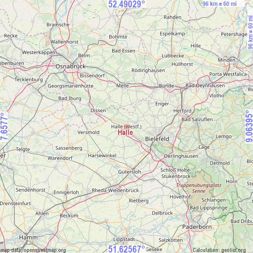
Halle GPS coordinates[2]
52° 3' 36.252" North, 8° 21' 38.988" East
| Map corner | latitude | longitude |
|---|---|---|
| Upper-left | 52.49029°, | 7.6577° |
| Center: | 52.06007°, | 8.36083° |
| Lower-right: | 51.62567°, | 9.06395° |
| Map W x H: | 96.1×96.1 km | = 59.7×59.7mi |
| max Lat: | 55.01917° ⇑27.4% North |
| Halle: | 52.06007° |
| min Lat: | ⇓72.6% South 47.40724° |
| min Long | Halle | max Long |
| 5.92978° | 8.36083° | 14.98853° |
| W 27.7%⇐ | ⇒72.3% E |
Elevation
Elevation of Halle is 129 m = 423 ft, and this is 120.1 m = 394 ft below average elevation for this country.
| Max E: |
1256 m = 4121 ft | 63.5% |
| Avg. | 249.1 m = 817 ft | |
| Halle | 129 m = 423 ft | |
Min E: |
-5 m = -16 ft | 36.5% |
See also: Germany elevation on elevation.city.
Geographical zone
Halle is located in North temperate zone (between Tropic of Cancer and the Arctic Circle). Distance of this North polar circle is 1612.6 km =1002 mi to North.| Distance of | km | miles | from Halle |
|---|---|---|---|
| North Pole | 4218.5 | 2621.3 | to North |
| Arctic Circle | 1612.6 | 1002 | to North |
| Tropic Cancer | 3182.6 | 1977.6 | to South |
| Equator | 5788.5 | 3596.8 | to South |


Nearby cities:
15 places around Halle: (largest is in red/bold)
• Bad Laer
19.5 km =12.1 mi,  283°
283°
• Bad Rothenfelde
14.7 km =9.1 mi,  295°
295°
• Bielefeld
12.2 km =7.6 mi,  104°
104°
• Borgholzhausen
6.3 km =3.9 mi,  320°
320°
• Dissen
12.6 km =7.8 mi, 299°
• Enger
16.2 km =10.1 mi,  56°
56°
• Gütersloh
17.1 km =10.6 mi,  175°
175°
• Harsewinkel
14.2 km =8.8 mi,  219°
219°
• Hilter
16.8 km =10.4 mi, 299°
• Melle
15.9 km =9.9 mi,  354°
354°
• Neuenkirchen
8.8 km =5.5 mi,  12°
12°
• Spenge
12.3 km =7.6 mi,  43°
43°
• Steinhagen
7.2 km =4.5 mi,  158°
158°
• Versmold
14.4 km =8.9 mi,  261°
261°
• Werther
4.4 km =2.7 mi, 63°
Sources, notices
• [Note1] Compared only with cities in Germany existing in our database
• [Src1] Map data: © OpenStreetMap contributors (CC-BY-SA)
• [Src2] Other city data from geonames.org with taken over terms of usage.
• [Src3] Geographical zone / Annual Mean Temperature by Robert A. Rohde @ Wikipedia
