Dissen geodata
Dissen (Lower Saxony) is a populated place; located in Germany in Europe/Berlin (GMT+2) time zone. With population of 9,265 people, there are 1744 cities with bigger population in this country. Compared to other cities in Germany, 73.2% of cities are located further ↓South; 74.1% of cities are located further →East and 67.1% of cities have higher elevation than Dissen. Note1
Administrative division(s):
- Level 1: Lower Saxony
- Level 3: Landkreis Osnabrück
- Level 4: Dissen am Teutoburger Wald


Dissen GPS coordinates[2]
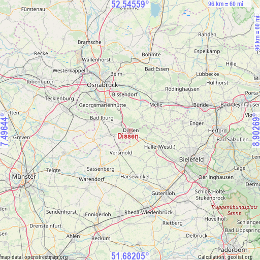
52° 6' 57.276" North, 8° 11' 58.416" East
| Map corner | latitude | longitude |
|---|---|---|
| Upper-left | 52.54559°, | 7.49644° |
| Center: | 52.11591°, | 8.19956° |
| Lower-right: | 51.68205°, | 8.90269° |
| Map W x H: | 96×96 km | = 59.7×59.7mi |
| max Lat: | 55.01917° ⇑26.8% North |
| Dissen: | 52.11591° |
| min Lat: | ⇓73.2% South 47.40724° |
| min Long | Dissen | max Long |
| 5.92978° | 8.19956° | 14.98853° |
| W 25.9%⇐ | ⇒74.1% E |
Elevation
Elevation of Dissen is 107 m = 351 ft, and this is 142.1 m = 466 ft below average elevation for this country.
| Max E: |
1256 m = 4121 ft | 67.1% |
| Avg. | 249.1 m = 817 ft | |
| Dissen | 107 m = 351 ft | |
Min E: |
-5 m = -16 ft | 32.9% |
See also: Germany elevation on elevation.city.
Geographical zone
Dissen is located in North temperate zone (between Tropic of Cancer and the Arctic Circle). Distance of this North polar circle is 1606.4 km =998.2 mi to North.| Distance of | km | miles | from Dissen |
|---|---|---|---|
| North Pole | 4212.3 | 2617.4 | to North |
| Arctic Circle | 1606.4 | 998.2 | to North |
| Tropic Cancer | 3188.8 | 1981.4 | to South |
| Equator | 5794.7 | 3600.7 | to South |


Nearby cities:
15 places around Dissen: (largest is in red/bold)
• Bad Iburg
11.6 km =7.2 mi,  291°
291°
• Bad Laer
8.1 km =5 mi,  257°
257°
• Bad Rothenfelde
2.2 km =1.4 mi,  272°
272°
• Bissendorf
13.2 km =8.2 mi,  350°
350°
• Borgholzhausen
7.1 km =4.4 mi,  101°
101°
• Georgsmarienhütte
14.3 km =8.9 mi,  312°
312°
• Glandorf
14.1 km =8.8 mi, 255°
• Halle
12.6 km =7.8 mi,  119°
119°
• Harsewinkel
17.2 km =10.7 mi,  173°
173°
• Hilter
4.2 km =2.6 mi,  301°
301°
• Lienen
15.2 km =9.4 mi,  284°
284°
• Melle
13.5 km =8.4 mi,  44°
44°
• Neuenkirchen
13.1 km =8.1 mi,  79°
79°
• Versmold
9 km =5.6 mi,  200°
200°
• Werther
15.5 km =9.6 mi,  105°
105°
Sources, notices
• [Note1] Compared only with cities in Germany existing in our database
• [Src1] Map data: © OpenStreetMap contributors (CC-BY-SA)
• [Src2] Other city data from geonames.org with taken over terms of usage.
• [Src3] Geographical zone / Annual Mean Temperature by Robert A. Rohde @ Wikipedia
