Steinhagen geodata
Steinhagen (North Rhine-Westphalia) is a seat of a fourth-order administrative division; located in Germany in Europe/Berlin (GMT+2) time zone. With population of 19,869 people, there are 784 cities with bigger population in this country. Compared to other cities in Germany, 72.2% of cities are located further ↓South; 72% of cities are located further →East and 69.2% of cities have higher elevation than Steinhagen. Note1
Administrative division(s):
- Level 1: North Rhine-Westphalia
- Level 2: Regierungsbezirk Detmold
- Level 3: Kreis Gütersloh
- Level 4: Steinhagen


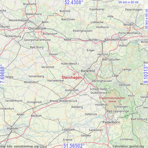
Steinhagen GPS coordinates[2]
52° 0' 0" North, 8° 24' 0" East
| Map corner | latitude | longitude |
|---|---|---|
| Upper-left | 52.4308°, | 7.69688° |
| Center: | 52°, | 8.4° |
| Lower-right: | 51.56502°, | 9.10313° |
| Map W x H: | 96.3×96.3 km | = 59.8×59.8mi |
| max Lat: | 55.01917° ⇑27.8% North |
| Steinhagen: | 52° |
| min Lat: | ⇓72.2% South 47.40724° |
| min Long | Steinhagen | max Long |
| 5.92978° | 8.4° | 14.98853° |
| W 28%⇐ | ⇒72% E |
Elevation
Elevation of Steinhagen is 96 m = 315 ft, and this is 153.1 m = 502 ft below average elevation for this country.
| Max E: |
1256 m = 4121 ft | 69.2% |
| Avg. | 249.1 m = 817 ft | |
| Steinhagen | 96 m = 315 ft | |
Min E: |
-5 m = -16 ft | 30.8% |
See also: Germany elevation on elevation.city.
Geographical zone
Steinhagen is located in North temperate zone (between Tropic of Cancer and the Arctic Circle). Distance of this North polar circle is 1619.3 km =1006.2 mi to North.| Distance of | km | miles | from Steinhagen |
|---|---|---|---|
| North Pole | 4225.2 | 2625.4 | to North |
| Arctic Circle | 1619.3 | 1006.2 | to North |
| Tropic Cancer | 3175.9 | 1973.4 | to South |
| Equator | 5781.9 | 3592.7 | to South |


Nearby cities:
15 places around Steinhagen: (largest is in red/bold)
• Bielefeld
9.8 km =6.1 mi,  67°
67°
• Borgholzhausen
13.3 km =8.3 mi,  329°
329°
• Dissen
18.8 km =11.7 mi,  313°
313°
• Enger
19 km =11.8 mi,  34°
34°
• Gütersloh
10.5 km =6.5 mi,  188°
188°
• Halle
7.2 km =4.5 mi,  338°
338°
• Harsewinkel
12.5 km =7.8 mi,  250°
250°
• Leopoldshöhe
20.5 km =12.7 mi,  86°
86°
• Neuenkirchen
15.3 km =9.5 mi,  357°
357°
• Oerlinghausen
18.7 km =11.6 mi,  105°
105°
• Rheda-Wiedenbrück
18.1 km =11.2 mi,  202°
202°
• Spenge
16.6 km =10.3 mi,  20°
20°
• Verl
15.2 km =9.4 mi,  148°
148°
• Versmold
17.5 km =10.9 mi,  284°
284°
• Werther
8.7 km =5.4 mi,  8°
8°
Sources, notices
• [Note1] Compared only with cities in Germany existing in our database
• [Src1] Map data: © OpenStreetMap contributors (CC-BY-SA)
• [Src2] Other city data from geonames.org with taken over terms of usage.
• [Src3] Geographical zone / Annual Mean Temperature by Robert A. Rohde @ Wikipedia
