Rüdnitz geodata
Rüdnitz (Brandenburg) is a seat of a fourth-order administrative division; located in Germany in Europe/Berlin (GMT+2) time zone. With population of 1,875 people, there are 5237 cities with bigger population in this country. Compared to other cities in Germany, 79.8% of cities are located further ↓South; 96.5% of cities are located further ←West and 75.5% of cities have higher elevation than Rüdnitz. Note1


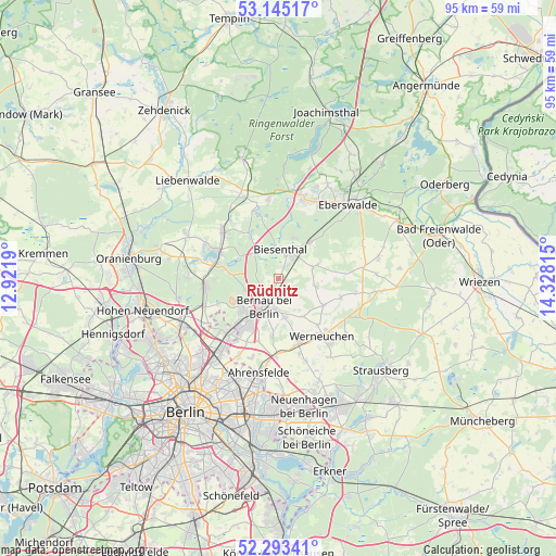
Rüdnitz GPS coordinates[2]
52° 43' 16.932" North, 13° 37' 30.072" East
| Map corner | latitude | longitude |
|---|---|---|
| Upper-left | 53.14517°, | 12.9219° |
| Center: | 52.72137°, | 13.62502° |
| Lower-right: | 52.29341°, | 14.32815° |
| Map W x H: | 94.7×94.7 km | = 58.8×58.8mi |
| max Lat: | 55.01917° ⇑20.2% North |
| Rüdnitz: | 52.72137° |
| min Lat: | ⇓79.8% South 47.40724° |
| min Long | Rüdnitz | max Long |
| 5.92978° | 13.62502° | 14.98853° |
| W 96.5%⇐ | ⇒3.5% E |
Elevation
Elevation of Rüdnitz is 61 m = 200 ft, and this is 188.1 m = 617 ft below average elevation for this country.
| Max E: |
1256 m = 4121 ft | 75.5% |
| Avg. | 249.1 m = 817 ft | |
| Rüdnitz | 61 m = 200 ft | |
Min E: |
-5 m = -16 ft | 24.5% |
See also: Germany elevation on elevation.city.
Geographical zone
Rüdnitz is located in North temperate zone (between Tropic of Cancer and the Arctic Circle). Distance of this North polar circle is 1539.1 km =956.4 mi to North.| Distance of | km | miles | from Rüdnitz |
|---|---|---|---|
| North Pole | 4145 | 2575.6 | to North |
| Arctic Circle | 1539.1 | 956.4 | to North |
| Tropic Cancer | 3256.1 | 2023.2 | to South |
| Equator | 5862.1 | 3642.5 | to South |


Nearby cities:
15 places around Rüdnitz: (largest is in red/bold)
• Ahrensfelde
16.4 km =10.2 mi,  190°
190°
• Bernau bei Berlin
5.3 km =3.3 mi,  208°
208°
• Biesenthal
5.1 km =3.2 mi,  14°
14°
• Buch
12.9 km =8 mi,  221°
221°
• Eberswalde
18.2 km =11.3 mi,  46°
46°
• Falkenberg
17.9 km =11.1 mi,  197°
197°
• Karow
15.8 km =9.8 mi, 217°
• Malchow
18.1 km =11.2 mi, 211°
• Marienwerder
13.5 km =8.4 mi,  352°
352°
• Melchow
8.2 km =5.1 mi,  41°
41°
• Stadtrandsiedlung Malchow
18.3 km =11.4 mi, 212°
• Wandlitz
11.5 km =7.1 mi,  281°
281°
• Wartenberg
17.9 km =11.1 mi, 204°
• Werftpfuhl
13.2 km =8.2 mi,  120°
120°
• Werneuchen
12.3 km =7.6 mi,  143°
143°
Sources, notices
• [Note1] Compared only with cities in Germany existing in our database
• [Src1] Map data: © OpenStreetMap contributors (CC-BY-SA)
• [Src2] Other city data from geonames.org with taken over terms of usage.
• [Src3] Geographical zone / Annual Mean Temperature by Robert A. Rohde @ Wikipedia
