Wennigsen geodata
Wennigsen (Lower Saxony) is a populated place; located in Germany in Europe/Berlin (GMT+2) time zone. With population of 14,137 people, there are 1126 cities with bigger population in this country. Compared to other cities in Germany, 74.9% of cities are located further ↓South; 56.6% of cities are located further →East and 70% of cities have higher elevation than Wennigsen. Note1
Administrative division(s):
- Level 1: Lower Saxony
- Level 3: Region Hannover
- Level 4: Wennigsen (Deister)


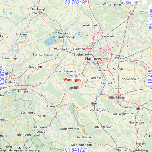
Wennigsen GPS coordinates[2]
52° 16' 26.544" North, 9° 34' 22.332" East
| Map corner | latitude | longitude |
|---|---|---|
| Upper-left | 52.70219°, | 8.86975° |
| Center: | 52.27404°, | 9.57287° |
| Lower-right: | 51.84172°, | 10.276° |
| Map W x H: | 95.7×95.7 km | = 59.5×59.5mi |
| max Lat: | 55.01917° ⇑25.1% North |
| Wennigsen: | 52.27404° |
| min Lat: | ⇓74.9% South 47.40724° |
| min Long | Wennigsen | max Long |
| 5.92978° | 9.57287° | 14.98853° |
| W 43.4%⇐ | ⇒56.6% E |
Elevation
Elevation of Wennigsen is 91 m = 299 ft, and this is 158.1 m = 519 ft below average elevation for this country.
| Max E: |
1256 m = 4121 ft | 70% |
| Avg. | 249.1 m = 817 ft | |
| Wennigsen | 91 m = 299 ft | |
Min E: |
-5 m = -16 ft | 30% |
See also: Germany elevation on elevation.city.
Geographical zone
Wennigsen is located in North temperate zone (between Tropic of Cancer and the Arctic Circle). Distance of this North polar circle is 1588.8 km =987.2 mi to North.| Distance of | km | miles | from Wennigsen |
|---|---|---|---|
| North Pole | 4194.7 | 2606.5 | to North |
| Arctic Circle | 1588.8 | 987.2 | to North |
| Tropic Cancer | 3206.4 | 1992.4 | to South |
| Equator | 5812.3 | 3611.6 | to South |


Nearby cities:
15 places around Wennigsen: (largest is in red/bold)
• Bad Münder am Deister
11.4 km =7.1 mi,  220°
220°
• Bad Nenndorf
14.9 km =9.3 mi,  297°
297°
• Barsinghausen
8.8 km =5.5 mi,  289°
289°
• Egestorf
4 km =2.5 mi, 288°
• Gehrden
4.8 km =3 mi,  22°
22°
• Groß Munzel
12 km =7.5 mi,  327°
327°
• Großgoltern
8.1 km =5 mi,  323°
323°
• Hemmingen
11.2 km =7 mi,  66°
66°
• Hülsede
14.6 km =9.1 mi,  259°
259°
• Lauenau
13.9 km =8.6 mi,  269°
269°
• Messenkamp
13.2 km =8.2 mi, 263°
• Pattensen
13.1 km =8.1 mi,  94°
94°
• Ronnenberg
7.5 km =4.7 mi,  48°
48°
• Seelze
13.7 km =8.5 mi,  6°
6°
• Springe
7.4 km =4.6 mi,  189°
189°
Sources, notices
• [Note1] Compared only with cities in Germany existing in our database
• [Src1] Map data: © OpenStreetMap contributors (CC-BY-SA)
• [Src2] Other city data from geonames.org with taken over terms of usage.
• [Src3] Geographical zone / Annual Mean Temperature by Robert A. Rohde @ Wikipedia
