Bad Münder am Deister geodata
Bad Münder am Deister (Lower Saxony) is a populated place; located in Germany in Europe/Berlin (GMT+2) time zone. With population of 18,726 people, there are 837 cities with bigger population in this country. Compared to other cities in Germany, 74% of cities are located further ↓South; 58.4% of cities are located further →East and 65.4% of cities have higher elevation than Bad Münder am Deister. Note1
Administrative division(s):
- Level 1: Lower Saxony
- Level 3: Landkreis Hameln-Pyrmont
- Level 4: Bad Münder am Deister


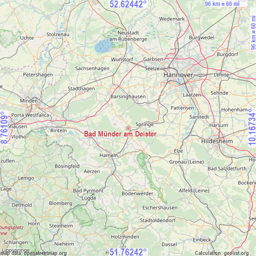
Bad Münder am Deister GPS coordinates[2]
52° 11' 43.836" North, 9° 27' 51.156" East
| Map corner | latitude | longitude |
|---|---|---|
| Upper-left | 52.62442°, | 8.76109° |
| Center: | 52.19551°, | 9.46421° |
| Lower-right: | 51.76242°, | 10.16734° |
| Map W x H: | 95.8×95.8 km | = 59.5×59.5mi |
| max Lat: | 55.01917° ⇑26% North |
| Bad Münder am Deister: | 52.19551° |
| min Lat: | ⇓74% South 47.40724° |
| min Long | Bad Münder am | max Long |
| 5.92978° | 9.46421° | 14.98853° |
| W 41.6%⇐ | ⇒58.4% E |
Elevation
Elevation of Bad Münder am Deister is 118 m = 387 ft, and this is 131.1 m = 430 ft below average elevation for this country.
| Max E: |
1256 m = 4121 ft | 65.4% |
| Avg. | 249.1 m = 817 ft | |
| Bad Münder am Deister | 118 m = 387 ft | |
Min E: |
-5 m = -16 ft | 34.6% |
See also: Germany elevation on elevation.city.
Geographical zone
Bad Münder am Deister is located in North temperate zone (between Tropic of Cancer and the Arctic Circle). Distance of this North polar circle is 1597.6 km =992.7 mi to North.| Distance of | km | miles | from Bad Münder am Deister |
|---|---|---|---|
| North Pole | 4203.5 | 2611.9 | to North |
| Arctic Circle | 1597.6 | 992.7 | to North |
| Tropic Cancer | 3197.7 | 1987 | to South |
| Equator | 5803.6 | 3606.2 | to South |


Nearby cities:
15 places around Bad Münder am Deister: (largest is in red/bold)
• Apelern
13.7 km =8.5 mi,  320°
320°
• Barsinghausen
11.7 km =7.3 mi,  355°
355°
• Coppenbrügge
10.3 km =6.4 mi,  146°
146°
• Egestorf
10.6 km =6.6 mi,  19°
19°
• Gehrden
16.1 km =10 mi,  35°
35°
• Großgoltern
15.4 km =9.6 mi,  9°
9°
• Hameln
12.6 km =7.8 mi,  215°
215°
• Hessisch Oldendorf
14.9 km =9.3 mi,  260°
260°
• Hülsede
9.2 km =5.7 mi,  310°
310°
• Lauenau
10.9 km =6.8 mi, 323°
• Messenkamp
9.2 km =5.7 mi, 321°
• Pohle
11.4 km =7.1 mi, 313°
• Rodenberg
14.8 km =9.2 mi,  330°
330°
• Springe
6.3 km =3.9 mi,  76°
76°
• Wennigsen
11.4 km =7.1 mi, 40°
Sources, notices
• [Note1] Compared only with cities in Germany existing in our database
• [Src1] Map data: © OpenStreetMap contributors (CC-BY-SA)
• [Src2] Other city data from geonames.org with taken over terms of usage.
• [Src3] Geographical zone / Annual Mean Temperature by Robert A. Rohde @ Wikipedia
