Egestorf geodata
Egestorf (Lower Saxony) is a populated place; located in Germany in Europe/Berlin (GMT+2) time zone. With population of 7,959 people, there are 1962 cities with bigger population in this country. Compared to other cities in Germany, 75% of cities are located further ↓South; 57.5% of cities are located further →East and 70.5% of cities have higher elevation than Egestorf. Note1


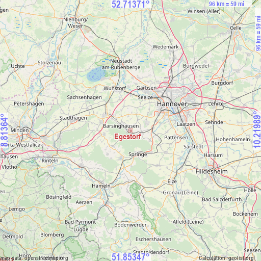
Egestorf GPS coordinates[2]
52° 17' 8.448" North, 9° 31' 0.336" East
| Map corner | latitude | longitude |
|---|---|---|
| Upper-left | 52.71371°, | 8.81364° |
| Center: | 52.28568°, | 9.51676° |
| Lower-right: | 51.85347°, | 10.21989° |
| Map W x H: | 95.6×95.6 km | = 59.4×59.4mi |
| max Lat: | 55.01917° ⇑25% North |
| Egestorf: | 52.28568° |
| min Lat: | ⇓75% South 47.40724° |
| min Long | Egestorf | max Long |
| 5.92978° | 9.51676° | 14.98853° |
| W 42.5%⇐ | ⇒57.5% E |
Elevation
Elevation of Egestorf is 88 m = 289 ft, and this is 161.1 m = 529 ft below average elevation for this country.
| Max E: |
1256 m = 4121 ft | 70.5% |
| Avg. | 249.1 m = 817 ft | |
| Egestorf | 88 m = 289 ft | |
Min E: |
-5 m = -16 ft | 29.5% |
See also: Germany elevation on elevation.city.
Geographical zone
Egestorf is located in North temperate zone (between Tropic of Cancer and the Arctic Circle). Distance of this North polar circle is 1587.6 km =986.5 mi to North.| Distance of | km | miles | from Egestorf |
|---|---|---|---|
| North Pole | 4193.4 | 2605.7 | to North |
| Arctic Circle | 1587.6 | 986.5 | to North |
| Tropic Cancer | 3207.7 | 1993.2 | to South |
| Equator | 5813.6 | 3612.4 | to South |


Nearby cities:
15 places around Egestorf: (largest is in red/bold)
• Apelern
12.3 km =7.6 mi,  272°
272°
• Bad Münder am Deister
10.6 km =6.6 mi,  199°
199°
• Bad Nenndorf
11 km =6.8 mi,  301°
301°
• Barsinghausen
4.8 km =3 mi,  289°
289°
• Gehrden
6.5 km =4 mi,  61°
61°
• Groß Munzel
9.3 km =5.8 mi,  343°
343°
• Großgoltern
5.3 km =3.3 mi,  348°
348°
• Hülsede
11.3 km =7 mi,  249°
249°
• Lauenau
10.1 km =6.3 mi,  262°
262°
• Messenkamp
9.7 km =6 mi, 252°
• Pohle
11.9 km =7.4 mi, 259°
• Rodenberg
11.3 km =7 mi,  284°
284°
• Ronnenberg
10.1 km =6.3 mi,  68°
68°
• Springe
9 km =5.6 mi,  163°
163°
• Wennigsen
4 km =2.5 mi,  108°
108°
Sources, notices
• [Note1] Compared only with cities in Germany existing in our database
• [Src1] Map data: © OpenStreetMap contributors (CC-BY-SA)
• [Src2] Other city data from geonames.org with taken over terms of usage.
• [Src3] Geographical zone / Annual Mean Temperature by Robert A. Rohde @ Wikipedia
