Seelze geodata
Seelze (Lower Saxony) is a populated place; located in Germany in Europe/Berlin (GMT+2) time zone. With population of 32,899 people, there are 411 cities with bigger population in this country. Compared to other cities in Germany, 76.1% of cities are located further ↓South; 56.2% of cities are located further →East and 78.9% of cities have higher elevation than Seelze. Note1


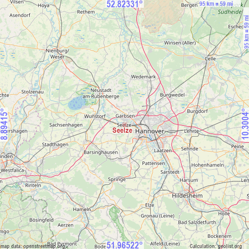
Seelze GPS coordinates[2]
52° 23' 46.86" North, 9° 35' 50.172" East
| Map corner | latitude | longitude |
|---|---|---|
| Upper-left | 52.82331°, | 8.89415° |
| Center: | 52.39635°, | 9.59727° |
| Lower-right: | 51.96522°, | 10.3004° |
| Map W x H: | 95.4×95.4 km | = 59.3×59.3mi |
| max Lat: | 55.01917° ⇑23.9% North |
| Seelze: | 52.39635° |
| min Lat: | ⇓76.1% South 47.40724° |
| min Long | Seelze | max Long |
| 5.92978° | 9.59727° | 14.98853° |
| W 43.8%⇐ | ⇒56.2% E |
Elevation
Elevation of Seelze is 50 m = 164 ft, and this is 199.1 m = 653 ft below average elevation for this country.
| Max E: |
1256 m = 4121 ft | 78.9% |
| Avg. | 249.1 m = 817 ft | |
| Seelze | 50 m = 164 ft | |
Min E: |
-5 m = -16 ft | 21.1% |
See also: Germany elevation on elevation.city.
Geographical zone
Seelze is located in North temperate zone (between Tropic of Cancer and the Arctic Circle). Distance of this North polar circle is 1575.2 km =978.8 mi to North.| Distance of | km | miles | from Seelze |
|---|---|---|---|
| North Pole | 4181.1 | 2598 | to North |
| Arctic Circle | 1575.2 | 978.8 | to North |
| Tropic Cancer | 3220 | 2000.8 | to South |
| Equator | 5825.9 | 3620 | to South |


Nearby cities:
15 places around Seelze: (largest is in red/bold)
• Auf der Horst
2.6 km =1.6 mi,  7°
7°
• Barsinghausen
14.7 km =9.1 mi,  223°
223°
• Egestorf
13.5 km =8.4 mi,  203°
203°
• Garbsen
2 km =1.2 mi,  345°
345°
• Garbsen-Mitte
3.4 km =2.1 mi, 7°
• Gehrden
9.2 km =5.7 mi,  178°
178°
• Groß Munzel
8.8 km =5.5 mi,  247°
247°
• Großgoltern
9.6 km =6 mi, 222°
• Hannover
9.7 km =6 mi,  107°
107°
• Haste
14 km =8.7 mi,  263°
263°
• Hemmingen
12.5 km =7.8 mi,  136°
136°
• Langenhagen
11.1 km =6.9 mi,  59°
59°
• Ronnenberg
9.4 km =5.8 mi,  155°
155°
• Wennigsen
13.7 km =8.5 mi,  186°
186°
• Wunstorf
11.4 km =7.1 mi,  285°
285°
Sources, notices
• [Note1] Compared only with cities in Germany existing in our database
• [Src1] Map data: © OpenStreetMap contributors (CC-BY-SA)
• [Src2] Other city data from geonames.org with taken over terms of usage.
• [Src3] Geographical zone / Annual Mean Temperature by Robert A. Rohde @ Wikipedia
