Springe geodata
Springe (Lower Saxony) is a seat of a fourth-order administrative division; located in Germany in Europe/Berlin (GMT+2) time zone. With population of 29,828 people, there are 468 cities with bigger population in this country. Compared to other cities in Germany, 74.2% of cities are located further ↓South; 57% of cities are located further →East and 66.7% of cities have higher elevation than Springe. Note1


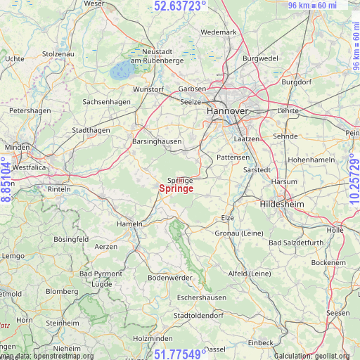
Springe GPS coordinates[2]
52° 12' 30.42" North, 9° 33' 14.976" East
| Map corner | latitude | longitude |
|---|---|---|
| Upper-left | 52.63723°, | 8.85104° |
| Center: | 52.20845°, | 9.55416° |
| Lower-right: | 51.77549°, | 10.25729° |
| Map W x H: | 95.8×95.8 km | = 59.5×59.5mi |
| max Lat: | 55.01917° ⇑25.8% North |
| Springe: | 52.20845° |
| min Lat: | ⇓74.2% South 47.40724° |
| min Long | Springe | max Long |
| 5.92978° | 9.55416° | 14.98853° |
| W 43%⇐ | ⇒57% E |
Elevation
Elevation of Springe is 110 m = 361 ft, and this is 139.1 m = 456 ft below average elevation for this country.
| Max E: |
1256 m = 4121 ft | 66.7% |
| Avg. | 249.1 m = 817 ft | |
| Springe | 110 m = 361 ft | |
Min E: |
-5 m = -16 ft | 33.3% |
See also: Germany elevation on elevation.city.
Geographical zone
Springe is located in North temperate zone (between Tropic of Cancer and the Arctic Circle). Distance of this North polar circle is 1596.1 km =991.8 mi to North.| Distance of | km | miles | from Springe |
|---|---|---|---|
| North Pole | 4202 | 2611 | to North |
| Arctic Circle | 1596.1 | 991.8 | to North |
| Tropic Cancer | 3199.1 | 1987.8 | to South |
| Equator | 5805 | 3607.1 | to South |


Nearby cities:
15 places around Springe: (largest is in red/bold)
• Bad Münder am Deister
6.3 km =3.9 mi,  256°
256°
• Barsinghausen
12.4 km =7.7 mi,  325°
325°
• Coppenbrügge
10 km =6.2 mi,  182°
182°
• Egestorf
9 km =5.6 mi,  343°
343°
• Elze
15.6 km =9.7 mi,  127°
127°
• Gehrden
12.1 km =7.5 mi,  15°
15°
• Großgoltern
14.3 km =8.9 mi,  345°
345°
• Hülsede
13.9 km =8.6 mi,  289°
289°
• Lauenau
14.5 km =9 mi,  300°
300°
• Messenkamp
13.2 km =8.2 mi, 295°
• Pattensen
15.6 km =9.7 mi,  66°
66°
• Pohle
15.7 km =9.8 mi, 294°
• Ronnenberg
14.1 km =8.8 mi,  29°
29°
• Salzhemmendorf
15.9 km =9.9 mi,  171°
171°
• Wennigsen
7.4 km =4.6 mi,  9°
9°
Sources, notices
• [Note1] Compared only with cities in Germany existing in our database
• [Src1] Map data: © OpenStreetMap contributors (CC-BY-SA)
• [Src2] Other city data from geonames.org with taken over terms of usage.
• [Src3] Geographical zone / Annual Mean Temperature by Robert A. Rohde @ Wikipedia
