Gehrden geodata
Gehrden (Lower Saxony) is a populated place; located in Germany in Europe/Berlin (GMT+2) time zone. With population of 14,955 people, there are 1066 cities with bigger population in this country. Compared to other cities in Germany, 75.3% of cities are located further ↓South; 56.1% of cities are located further →East and 72% of cities have higher elevation than Gehrden. Note1


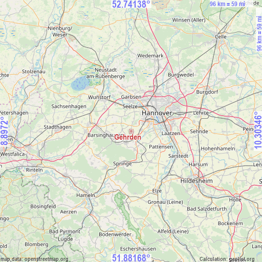
Gehrden GPS coordinates[2]
52° 18' 49.032" North, 9° 36' 1.188" East
| Map corner | latitude | longitude |
|---|---|---|
| Upper-left | 52.74138°, | 8.8972° |
| Center: | 52.31362°, | 9.60033° |
| Lower-right: | 51.88168°, | 10.30346° |
| Map W x H: | 95.6×95.6 km | = 59.4×59.4mi |
| max Lat: | 55.01917° ⇑24.7% North |
| Gehrden: | 52.31362° |
| min Lat: | ⇓75.3% South 47.40724° |
| min Long | Gehrden | max Long |
| 5.92978° | 9.60033° | 14.98853° |
| W 43.9%⇐ | ⇒56.1% E |
Elevation
Elevation of Gehrden is 78 m = 256 ft, and this is 171.1 m = 561 ft below average elevation for this country.
| Max E: |
1256 m = 4121 ft | 72% |
| Avg. | 249.1 m = 817 ft | |
| Gehrden | 78 m = 256 ft | |
Min E: |
-5 m = -16 ft | 28% |
See also: Germany elevation on elevation.city.
Geographical zone
Gehrden is located in North temperate zone (between Tropic of Cancer and the Arctic Circle). Distance of this North polar circle is 1584.4 km =984.5 mi to North.| Distance of | km | miles | from Gehrden |
|---|---|---|---|
| North Pole | 4190.3 | 2603.7 | to North |
| Arctic Circle | 1584.4 | 984.5 | to North |
| Tropic Cancer | 3210.8 | 1995.1 | to South |
| Equator | 5816.7 | 3614.3 | to South |


Nearby cities:
15 places around Gehrden: (largest is in red/bold)
• Auf der Horst
11.8 km =7.3 mi,  0°
0°
• Barsinghausen
10.3 km =6.4 mi,  261°
261°
• Egestorf
6.5 km =4 mi,  241°
241°
• Garbsen
11.2 km =7 mi,  356°
356°
• Garbsen-Mitte
12.6 km =7.8 mi, 1°
• Groß Munzel
10.1 km =6.3 mi,  304°
304°
• Großgoltern
7.1 km =4.4 mi,  287°
287°
• Hannover
11 km =6.8 mi,  54°
54°
• Hemmingen
8.4 km =5.2 mi,  89°
89°
• Laatzen
13.4 km =8.3 mi, 89°
• Pattensen
12.4 km =7.7 mi,  116°
116°
• Ronnenberg
3.8 km =2.4 mi,  80°
80°
• Seelze
9.2 km =5.7 mi, 358°
• Springe
12.1 km =7.5 mi,  195°
195°
• Wennigsen
4.8 km =3 mi, 202°
Sources, notices
• [Note1] Compared only with cities in Germany existing in our database
• [Src1] Map data: © OpenStreetMap contributors (CC-BY-SA)
• [Src2] Other city data from geonames.org with taken over terms of usage.
• [Src3] Geographical zone / Annual Mean Temperature by Robert A. Rohde @ Wikipedia
