Uhyst geodata
Uhyst (Saxony) is a populated place; located in Germany in Europe/Berlin (GMT+2) time zone. With population of 1,169 people, there are 6649 cities with bigger population in this country. Compared to other cities in Germany, 64.2% of cities are located further ↓South; 99.3% of cities are located further ←West and 63.2% of cities have higher elevation than Uhyst. Note1


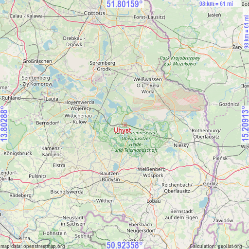
Uhyst GPS coordinates[2]
51° 21' 52.884" North, 14° 30' 21.6" East
| Map corner | latitude | longitude |
|---|---|---|
| Upper-left | 51.80159°, | 13.80288° |
| Center: | 51.36469°, | 14.506° |
| Lower-right: | 50.92358°, | 15.20913° |
| Map W x H: | 97.6×97.6 km | = 60.6×60.6mi |
| max Lat: | 55.01917° ⇑35.8% North |
| Uhyst: | 51.36469° |
| min Lat: | ⇓64.2% South 47.40724° |
| min Long | Uhyst | max Long |
| 5.92978° | 14.506° | 14.98853° |
| W 99.3%⇐ | ⇒0.7% E |
Elevation
Elevation of Uhyst is 131 m = 430 ft, and this is 118.1 m = 387 ft below average elevation for this country.
| Max E: |
1256 m = 4121 ft | 63.2% |
| Avg. | 249.1 m = 817 ft | |
| Uhyst | 131 m = 430 ft | |
Min E: |
-5 m = -16 ft | 36.8% |
See also: Germany elevation on elevation.city.
Geographical zone
Uhyst is located in North temperate zone (between Tropic of Cancer and the Arctic Circle). Distance of this North polar circle is 1690 km =1050.1 mi to North.| Distance of | km | miles | from Uhyst |
|---|---|---|---|
| North Pole | 4295.8 | 2669.3 | to North |
| Arctic Circle | 1690 | 1050.1 | to North |
| Tropic Cancer | 3105.3 | 1929.5 | to South |
| Equator | 5711.2 | 3548.8 | to South |


Nearby cities:
15 places around Uhyst: (largest is in red/bold)
• Boxberg
6.5 km =4 mi,  48°
48°
• Großdubrau
12.7 km =7.9 mi,  194°
194°
• Guttau
12.4 km =7.7 mi,  161°
161°
• Klitten
7.1 km =4.4 mi,  102°
102°
• Knappenrode
13.6 km =8.5 mi,  288°
288°
• Königswartha
13.8 km =8.6 mi,  243°
243°
• Lohsa
7.6 km =4.7 mi, 285°
• Malschwitz
14.2 km =8.8 mi,  175°
175°
• Mücka
14.5 km =9 mi,  111°
111°
• Neschwitz
16.2 km =10.1 mi,  229°
229°
• Puschwitz
18.7 km =11.6 mi, 229°
• Radibor
15.3 km =9.5 mi,  209°
209°
• Schleife
18.8 km =11.7 mi,  5°
5°
• Weißwasser
18.1 km =11.2 mi,  30°
30°
• Wittichenau
18.3 km =11.4 mi,  277°
277°
Sources, notices
• [Note1] Compared only with cities in Germany existing in our database
• [Src1] Map data: © OpenStreetMap contributors (CC-BY-SA)
• [Src2] Other city data from geonames.org with taken over terms of usage.
• [Src3] Geographical zone / Annual Mean Temperature by Robert A. Rohde @ Wikipedia
