Sontra geodata
Sontra (Hesse) is a populated place; located in Germany in Europe/Berlin (GMT+2) time zone. With population of 8,624 people, there are 1853 cities with bigger population in this country. Compared to other cities in Germany, 59.4% of cities are located further ↓South; 50.9% of cities are located further →East and 50% of cities have lower elevation than Sontra. Note1
Administrative division(s):
- Level 1: Hesse
- Level 2: Regierungsbezirk Kassel
- Level 3: Werra-Meißner-Kreis
- Level 4: Sontra


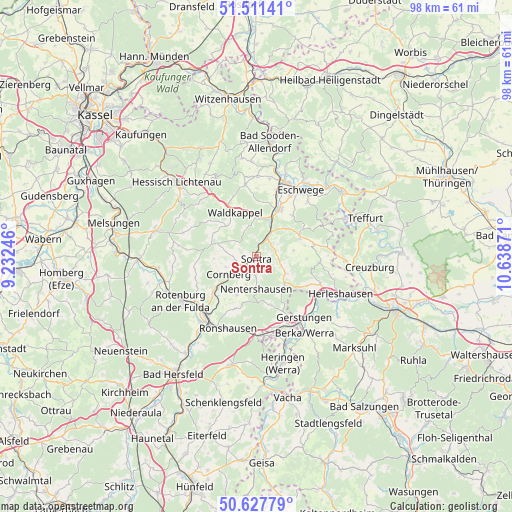
Sontra GPS coordinates[2]
51° 4' 18.156" North, 9° 56' 8.088" East
| Map corner | latitude | longitude |
|---|---|---|
| Upper-left | 51.51141°, | 9.23246° |
| Center: | 51.07171°, | 9.93558° |
| Lower-right: | 50.62779°, | 10.63871° |
| Map W x H: | 98.2×98.2 km | = 61×61mi |
| max Lat: | 55.01917° ⇑40.6% North |
| Sontra: | 51.07171° |
| min Lat: | ⇓59.4% South 47.40724° |
| min Long | Sontra | max Long |
| 5.92978° | 9.93558° | 14.98853° |
| W 49.1%⇐ | ⇒50.9% E |
Elevation
Elevation of Sontra is 225 m = 738 ft, and this is 24.1 m = 79 ft below average elevation for this country.
| Max E: |
1256 m = 4121 ft | 50% |
| Avg. | 249.1 m = 817 ft | |
| Sontra | 225 m = 738 ft | |
Min E: |
-5 m = -16 ft | 50% |
See also: Germany elevation on elevation.city.
Geographical zone
Sontra is located in North temperate zone (between Tropic of Cancer and the Arctic Circle). Distance of this North polar circle is 1722.5 km =1070.3 mi to North.| Distance of | km | miles | from Sontra |
|---|---|---|---|
| North Pole | 4328.4 | 2689.5 | to North |
| Arctic Circle | 1722.5 | 1070.3 | to North |
| Tropic Cancer | 3072.7 | 1909.3 | to South |
| Equator | 5678.6 | 3528.5 | to South |


Nearby cities:
15 places around Sontra: (largest is in red/bold)
• Bebra
14.6 km =9.1 mi,  222°
222°
• Breitenbach
16.7 km =10.4 mi, 219°
• Cornberg
6.2 km =3.9 mi,  237°
237°
• Dankmarshausen
17.2 km =10.7 mi,  160°
160°
• Eschwege
14.9 km =9.3 mi,  33°
33°
• Gerstungen
14.8 km =9.2 mi,  141°
141°
• Großensee
15.5 km =9.6 mi,  171°
171°
• Herleshausen
17.8 km =11.1 mi,  114°
114°
• Ifta
17.3 km =10.7 mi,  91°
91°
• Lauchröden
17.7 km =11 mi,  119°
119°
• Nentershausen
6.1 km =3.8 mi,  181°
181°
• Ronshausen
14.8 km =9.2 mi,  203°
203°
• Rotenburg an der Fulda
16.8 km =10.4 mi, 239°
• Waldkappel
9.1 km =5.7 mi,  333°
333°
• Weißenborn
13.9 km =8.6 mi,  64°
64°
Sources, notices
• [Note1] Compared only with cities in Germany existing in our database
• [Src1] Map data: © OpenStreetMap contributors (CC-BY-SA)
• [Src2] Other city data from geonames.org with taken over terms of usage.
• [Src3] Geographical zone / Annual Mean Temperature by Robert A. Rohde @ Wikipedia
