Runkel geodata
Runkel (Hesse) is a populated place; located in Germany in Europe/Berlin (GMT+2) time zone. With population of 9,872 people, there are 1648 cities with bigger population in this country. Compared to other cities in Germany, 54.5% of cities are located further ↑North; 74.7% of cities are located further →East and 64.1% of cities have higher elevation than Runkel. Note1
Administrative division(s):
- Level 1: Hesse
- Level 2: Regierungsbezirk Gießen
- Level 3: Landkreis Limburg-Weilburg
- Level 4: Runkel


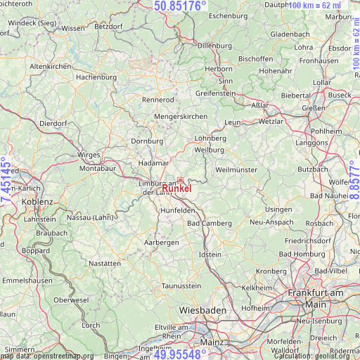
Runkel GPS coordinates[2]
50° 24' 20.664" North, 8° 9' 16.452" East
| Map corner | latitude | longitude |
|---|---|---|
| Upper-left | 50.85176°, | 7.45145° |
| Center: | 50.40574°, | 8.15457° |
| Lower-right: | 49.95548°, | 8.8577° |
| Map W x H: | 99.7×99.7 km | = 62×62mi |
| max Lat: | 55.01917° ⇑54.5% North |
| Runkel: | 50.40574° |
| min Lat: | ⇓45.5% South 47.40724° |
| min Long | Runkel | max Long |
| 5.92978° | 8.15457° | 14.98853° |
| W 25.3%⇐ | ⇒74.7% E |
Elevation
Elevation of Runkel is 126 m = 413 ft, and this is 123.1 m = 404 ft below average elevation for this country.
| Max E: |
1256 m = 4121 ft | 64.1% |
| Avg. | 249.1 m = 817 ft | |
| Runkel | 126 m = 413 ft | |
Min E: |
-5 m = -16 ft | 35.9% |
See also: Germany elevation on elevation.city.
Geographical zone
Runkel is located in North temperate zone (between Tropic of Cancer and the Arctic Circle). Distance of this North polar circle is 1796.6 km =1116.4 mi to North.| Distance of | km | miles | from Runkel |
|---|---|---|---|
| North Pole | 4402.5 | 2735.6 | to North |
| Arctic Circle | 1796.6 | 1116.4 | to North |
| Tropic Cancer | 2998.7 | 1863.3 | to South |
| Equator | 5604.6 | 3482.5 | to South |


Nearby cities:
15 places around Runkel: (largest is in red/bold)
• Aull
11 km =6.8 mi,  258°
258°
• Dehrn
4.3 km =2.7 mi,  292°
292°
• Diez
11 km =6.8 mi,  251°
251°
• Elz
8.7 km =5.4 mi,  278°
278°
• Flacht
10 km =6.2 mi,  227°
227°
• Gückingen
10.6 km =6.6 mi, 261°
• Hadamar
9.1 km =5.7 mi,  299°
299°
• Holzheim
9.4 km =5.8 mi, 232°
• Limburg an der Lahn
7.8 km =4.8 mi, 251°
• Netzbach
10.6 km =6.6 mi,  201°
201°
• Niederneisen
10.9 km =6.8 mi,  222°
222°
• Oberneisen
10.5 km =6.5 mi,  211°
211°
• Steeden
2.2 km =1.4 mi, 299°
• Villmar
3.1 km =1.9 mi,  117°
117°
• Weinbach
10.3 km =6.4 mi,  69°
69°
Sources, notices
• [Note1] Compared only with cities in Germany existing in our database
• [Src1] Map data: © OpenStreetMap contributors (CC-BY-SA)
• [Src2] Other city data from geonames.org with taken over terms of usage.
• [Src3] Geographical zone / Annual Mean Temperature by Robert A. Rohde @ Wikipedia
