Villmar geodata
Villmar (Hesse) is a seat of a fourth-order administrative division; located in Germany in Europe/Berlin (GMT+2) time zone. With population of 7,334 people, there are 2106 cities with bigger population in this country. Compared to other cities in Germany, 54.8% of cities are located further ↑North; 74.2% of cities are located further →East and 60.6% of cities have higher elevation than Villmar. Note1
Administrative division(s):
- Level 1: Hesse
- Level 2: Regierungsbezirk Gießen
- Level 3: Landkreis Limburg-Weilburg
- Level 4: Villmar


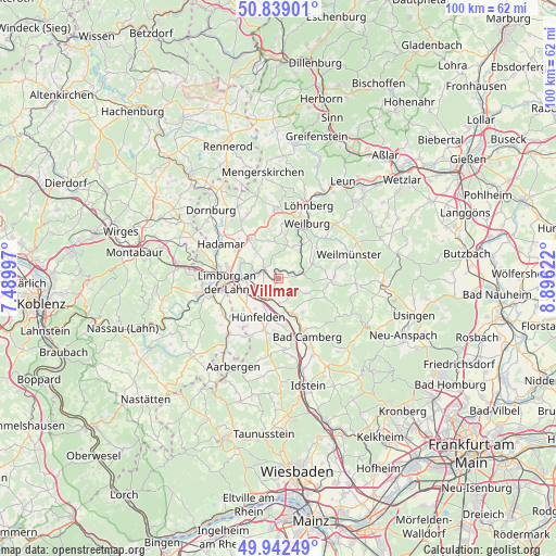
Villmar GPS coordinates[2]
50° 23' 34.332" North, 8° 11' 35.16" East
| Map corner | latitude | longitude |
|---|---|---|
| Upper-left | 50.83901°, | 7.48997° |
| Center: | 50.39287°, | 8.1931° |
| Lower-right: | 49.94249°, | 8.89622° |
| Map W x H: | 99.7×99.7 km | = 62×62mi |
| max Lat: | 55.01917° ⇑54.8% North |
| Villmar: | 50.39287° |
| min Lat: | ⇓45.2% South 47.40724° |
| min Long | Villmar | max Long |
| 5.92978° | 8.1931° | 14.98853° |
| W 25.8%⇐ | ⇒74.2% E |
Elevation
Elevation of Villmar is 148 m = 486 ft, and this is 101.1 m = 332 ft below average elevation for this country.
| Max E: |
1256 m = 4121 ft | 60.6% |
| Avg. | 249.1 m = 817 ft | |
| Villmar | 148 m = 486 ft | |
Min E: |
-5 m = -16 ft | 39.4% |
See also: Germany elevation on elevation.city.
Geographical zone
Villmar is located in North temperate zone (between Tropic of Cancer and the Arctic Circle). Distance of this North polar circle is 1798 km =1117.2 mi to North.| Distance of | km | miles | from Villmar |
|---|---|---|---|
| North Pole | 4403.9 | 2736.5 | to North |
| Arctic Circle | 1798 | 1117.2 | to North |
| Tropic Cancer | 2997.2 | 1862.4 | to South |
| Equator | 5603.2 | 3481.7 | to South |


Nearby cities:
15 places around Villmar: (largest is in red/bold)
• Bad Camberg
11.9 km =7.4 mi,  153°
153°
• Dehrn
7.4 km =4.6 mi,  294°
294°
• Elz
11.6 km =7.2 mi,  283°
283°
• Flacht
11.4 km =7.1 mi,  242°
242°
• Hadamar
12.2 km =7.6 mi,  298°
298°
• Holzheim
11.1 km =6.9 mi,  247°
247°
• Kaltenholzhausen
12.3 km =7.6 mi,  212°
212°
• Limburg an der Lahn
10.2 km =6.3 mi,  264°
264°
• Netzbach
10.7 km =6.6 mi,  217°
217°
• Niederneisen
12.1 km =7.5 mi, 236°
• Oberneisen
11.1 km =6.9 mi,  227°
227°
• Runkel
3.1 km =1.9 mi, 297°
• Steeden
5.3 km =3.3 mi, 298°
• Weilburg
11.3 km =7 mi,  25°
25°
• Weinbach
8.6 km =5.3 mi,  53°
53°
Sources, notices
• [Note1] Compared only with cities in Germany existing in our database
• [Src1] Map data: © OpenStreetMap contributors (CC-BY-SA)
• [Src2] Other city data from geonames.org with taken over terms of usage.
• [Src3] Geographical zone / Annual Mean Temperature by Robert A. Rohde @ Wikipedia
