Endschütz geodata
Endschütz (Thuringia) is a seat of a fourth-order administrative division; located in Germany in Europe/Berlin (GMT+2) time zone. With population of 388 people, there are 9729 cities with bigger population in this country. Compared to other cities in Germany, 53.9% of cities are located further ↓South; 83.7% of cities are located further ←West and 59.5% of cities have lower elevation than Endschütz. Note1


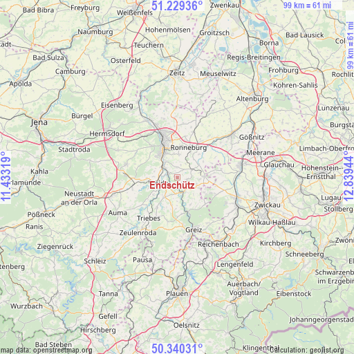
Endschütz GPS coordinates[2]
50° 47' 13.02" North, 12° 8' 10.716" East
| Map corner | latitude | longitude |
|---|---|---|
| Upper-left | 51.22936°, | 11.43319° |
| Center: | 50.78695°, | 12.13631° |
| Lower-right: | 50.34031°, | 12.83944° |
| Map W x H: | 98.9×98.9 km | = 61.5×61.5mi |
| max Lat: | 55.01917° ⇑46.1% North |
| Endschütz: | 50.78695° |
| min Lat: | ⇓53.9% South 47.40724° |
| min Long | Endschütz | max Long |
| 5.92978° | 12.13631° | 14.98853° |
| W 83.7%⇐ | ⇒16.3% E |
Elevation
Elevation of Endschütz is 287 m = 942 ft, and this is 37.9 m = 124 ft above average elevation for this country.
| Max E: |
1256 m = 4121 ft | 40.5% |
| Endschütz | 287 m 942 ft | |
| Avg. | 249.1 m = 817 ft | |
Min E: |
-5 m = -16 ft | 59.5% |
See also: Germany elevation on elevation.city.
Geographical zone
Endschütz is located in North temperate zone (between Tropic of Cancer and the Arctic Circle). Distance of this North polar circle is 1754.2 km =1090 mi to North.| Distance of | km | miles | from Endschütz |
|---|---|---|---|
| North Pole | 4360.1 | 2709.2 | to North |
| Arctic Circle | 1754.2 | 1090 | to North |
| Tropic Cancer | 3041.1 | 1889.7 | to South |
| Equator | 5647 | 3508.9 | to South |


Nearby cities:
15 places around Endschütz: (largest is in red/bold)
• Berga
4.4 km =2.7 mi,  153°
153°
• Braunichswalde
5.8 km =3.6 mi,  75°
75°
• Crimla
6.2 km =3.9 mi,  283°
283°
• Gauern
4.5 km =2.8 mi,  95°
95°
• Hilbersdorf
3.4 km =2.1 mi,  16°
16°
• Hohenölsen
6.2 km =3.9 mi,  215°
215°
• Neugernsdorf
7.8 km =4.8 mi,  181°
181°
• Rückersdorf
7.1 km =4.4 mi,  56°
56°
• Seelingstädt
7.7 km =4.8 mi, 101°
• Steinsdorf
7.3 km =4.5 mi,  235°
235°
• Teichwitz
5.5 km =3.4 mi, 222°
• Weida
5.5 km =3.4 mi,  255°
255°
• Wildetaube
7.9 km =4.9 mi,  190°
190°
• Wünschendorf
2.9 km =1.8 mi,  291°
291°
• Zedlitz
8 km =5 mi, 294°
Sources, notices
• [Note1] Compared only with cities in Germany existing in our database
• [Src1] Map data: © OpenStreetMap contributors (CC-BY-SA)
• [Src2] Other city data from geonames.org with taken over terms of usage.
• [Src3] Geographical zone / Annual Mean Temperature by Robert A. Rohde @ Wikipedia
