Wechselburg geodata
Wechselburg (Saxony) is a seat of a fourth-order administrative division; located in Germany in Europe/Berlin (GMT+2) time zone. With population of 2,223 people, there are 4778 cities with bigger population in this country. Compared to other cities in Germany, 58.2% of cities are located further ↓South; 90.5% of cities are located further ←West and 55.7% of cities have higher elevation than Wechselburg. Note1


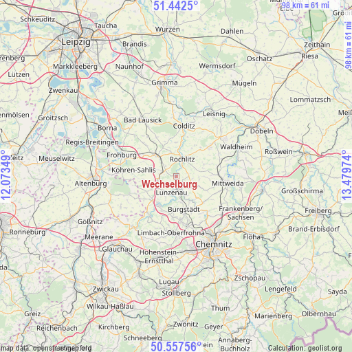
Wechselburg GPS coordinates[2]
51° 0' 7.704" North, 12° 46' 35.796" East
| Map corner | latitude | longitude |
|---|---|---|
| Upper-left | 51.4425°, | 12.07349° |
| Center: | 51.00214°, | 12.77661° |
| Lower-right: | 50.55756°, | 13.47974° |
| Map W x H: | 98.4×98.4 km | = 61.1×61.1mi |
| max Lat: | 55.01917° ⇑41.8% North |
| Wechselburg: | 51.00214° |
| min Lat: | ⇓58.2% South 47.40724° |
| min Long | Wechselburg | max Long |
| 5.92978° | 12.77661° | 14.98853° |
| W 90.5%⇐ | ⇒9.5% E |
Elevation
Elevation of Wechselburg is 184 m = 604 ft, and this is 65.1 m = 214 ft below average elevation for this country.
| Max E: |
1256 m = 4121 ft | 55.7% |
| Avg. | 249.1 m = 817 ft | |
| Wechselburg | 184 m = 604 ft | |
Min E: |
-5 m = -16 ft | 44.3% |
See also: Germany elevation on elevation.city.
Geographical zone
Wechselburg is located in North temperate zone (between Tropic of Cancer and the Arctic Circle). Distance of this North polar circle is 1730.3 km =1075.2 mi to North.| Distance of | km | miles | from Wechselburg |
|---|---|---|---|
| North Pole | 4336.2 | 2694.4 | to North |
| Arctic Circle | 1730.3 | 1075.2 | to North |
| Tropic Cancer | 3065 | 1904.5 | to South |
| Equator | 5670.9 | 3523.7 | to South |


Nearby cities:
15 places around Wechselburg: (largest is in red/bold)
• Burgstädt
10.1 km =6.3 mi,  168°
168°
• Claußnitz
10.7 km =6.6 mi,  135°
135°
• Erlau
11.8 km =7.3 mi,  86°
86°
• Geithain
8.1 km =5 mi,  316°
316°
• Hartmannsdorf
11.5 km =7.1 mi, 171°
• Königsfeld
7.4 km =4.6 mi,  345°
345°
• Lunzenau
4.6 km =2.9 mi,  198°
198°
• Mühlau
11.4 km =7.1 mi,  183°
183°
• Narsdorf
4.5 km =2.8 mi,  291°
291°
• Niederfrohna
12.1 km =7.5 mi, 200°
• Penig
9.2 km =5.7 mi,  213°
213°
• Rochlitz
5.5 km =3.4 mi,  15°
15°
• Seelitz
4.5 km =2.8 mi,  38°
38°
• Taura
10.8 km =6.7 mi,  151°
151°
• Zettlitz
8.2 km =5.1 mi,  28°
28°
Sources, notices
• [Note1] Compared only with cities in Germany existing in our database
• [Src1] Map data: © OpenStreetMap contributors (CC-BY-SA)
• [Src2] Other city data from geonames.org with taken over terms of usage.
• [Src3] Geographical zone / Annual Mean Temperature by Robert A. Rohde @ Wikipedia
