Erlau geodata
Erlau (Saxony) is a seat of a fourth-order administrative division; located in Germany in Europe/Berlin (GMT+2) time zone. With population of 3,638 people, there are 3512 cities with bigger population in this country. Compared to other cities in Germany, 58.3% of cities are located further ↓South; 91.8% of cities are located further ←West and 64% of cities have lower elevation than Erlau. Note1


Erlau GPS coordinates[2]
51° 0' 33.768" North, 12° 56' 43.764" East
| Map corner | latitude | longitude |
|---|---|---|
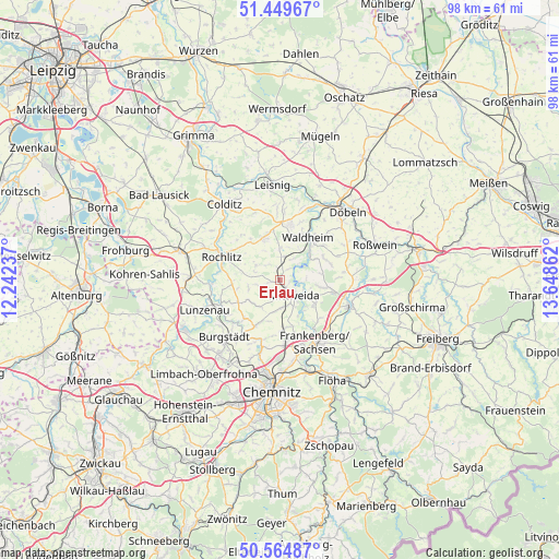
| Upper-left | 51.44967°, | 12.24237° |
| Center: | 51.00938°, | 12.94549° |
| Lower-right: | 50.56487°, | 13.64862° |
| Map W x H: | 98.4×98.4 km | = 61.1×61.1mi |
| max Lat: | 55.01917° ⇑41.7% North |
| Erlau: | 51.00938° |
| min Lat: | ⇓58.3% South 47.40724° |
| min Long | Erlau | max Long |
| 5.92978° | 12.94549° | 14.98853° |
| W 91.8%⇐ | ⇒8.2% E |
Elevation
Elevation of Erlau is 315 m = 1033 ft, and this is 65.9 m = 216 ft above average elevation for this country.
| Max E: |
1256 m = 4121 ft | 36% |
| Erlau | 315 m 1033 ft | |
| Avg. | 249.1 m = 817 ft | |
Min E: |
-5 m = -16 ft | 64% |
See also: Germany elevation on elevation.city.
Geographical zone
Erlau is located in North temperate zone (between Tropic of Cancer and the Arctic Circle). Distance of this North polar circle is 1729.5 km =1074.7 mi to North.| Distance of | km | miles | from Erlau |
|---|---|---|---|
| North Pole | 4335.4 | 2693.9 | to North |
| Arctic Circle | 1729.5 | 1074.7 | to North |
| Tropic Cancer | 3065.8 | 1905 | to South |
| Equator | 5671.7 | 3524.2 | to South |


Nearby cities:
15 places around Erlau: (largest is in red/bold)
• Altmittweida
4.8 km =3 mi,  176°
176°
• Claußnitz
9.5 km =5.9 mi,  207°
207°
• Frankenberg
12.6 km =7.8 mi,  148°
148°
• Geringswalde
8 km =5 mi,  340°
340°
• Gersdorf
11.4 km =7.1 mi,  357°
357°
• Hartha
10.1 km =6.3 mi,  11°
11°
• Kriebstein
6.7 km =4.2 mi,  47°
47°
• Mittweida
3.3 km =2.1 mi,  140°
140°
• Rochlitz
11.3 km =7 mi,  293°
293°
• Rossau
8.5 km =5.3 mi,  97°
97°
• Seelitz
9.4 km =5.8 mi, 286°
• Taura
12.3 km =7.6 mi, 212°
• Waldheim
8.8 km =5.5 mi,  36°
36°
• Wechselburg
11.8 km =7.3 mi,  266°
266°
• Zettlitz
10.1 km =6.3 mi,  309°
309°
Sources, notices
• [Note1] Compared only with cities in Germany existing in our database
• [Src1] Map data: © OpenStreetMap contributors (CC-BY-SA)
• [Src2] Other city data from geonames.org with taken over terms of usage.
• [Src3] Geographical zone / Annual Mean Temperature by Robert A. Rohde @ Wikipedia
