Narsdorf geodata
Narsdorf (Saxony) is a seat of a fourth-order administrative division; located in Germany in Europe/Berlin (GMT+2) time zone. With population of 1,917 people, there are 5184 cities with bigger population in this country. Compared to other cities in Germany, 58.3% of cities are located further ↓South; 89.9% of cities are located further ←West and 55.2% of cities have lower elevation than Narsdorf. Note1


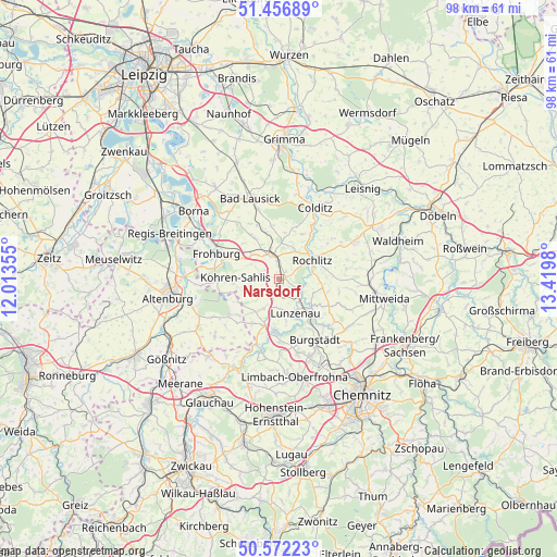
Narsdorf GPS coordinates[2]
51° 1' 0.012" North, 12° 43' 0.012" East
| Map corner | latitude | longitude |
|---|---|---|
| Upper-left | 51.45689°, | 12.01355° |
| Center: | 51.01667°, | 12.71667° |
| Lower-right: | 50.57223°, | 13.4198° |
| Map W x H: | 98.4×98.4 km | = 61.1×61.1mi |
| max Lat: | 55.01917° ⇑41.7% North |
| Narsdorf: | 51.01667° |
| min Lat: | ⇓58.3% South 47.40724° |
| min Long | Narsdorf | max Long |
| 5.92978° | 12.71667° | 14.98853° |
| W 89.9%⇐ | ⇒10.1% E |
Elevation
Elevation of Narsdorf is 259 m = 850 ft, and this is 9.9 m = 32 ft above average elevation for this country.
| Max E: |
1256 m = 4121 ft | 44.8% |
| Narsdorf | 259 m 850 ft | |
| Avg. | 249.1 m = 817 ft | |
Min E: |
-5 m = -16 ft | 55.2% |
See also: Germany elevation on elevation.city.
Geographical zone
Narsdorf is located in North temperate zone (between Tropic of Cancer and the Arctic Circle). Distance of this North polar circle is 1728.7 km =1074.2 mi to North.| Distance of | km | miles | from Narsdorf |
|---|---|---|---|
| North Pole | 4334.5 | 2693.3 | to North |
| Arctic Circle | 1728.7 | 1074.2 | to North |
| Tropic Cancer | 3066.6 | 1905.5 | to South |
| Equator | 5672.5 | 3524.7 | to South |


Nearby cities:
15 places around Narsdorf: (largest is in red/bold)
• Burgstädt
13.1 km =8.1 mi,  151°
151°
• Frohburg
12 km =7.5 mi,  292°
292°
• Frohnsdorf
12.7 km =7.9 mi,  229°
229°
• Geithain
4.5 km =2.8 mi,  342°
342°
• Jückelberg
11.7 km =7.3 mi,  211°
211°
• Königsfeld
6 km =3.7 mi,  22°
22°
• Langenleuba-Niederhain
11 km =6.8 mi, 234°
• Lunzenau
6.6 km =4.1 mi,  155°
155°
• Mühlau
13.4 km =8.3 mi, 164°
• Niederfrohna
13 km =8.1 mi,  180°
180°
• Penig
9.3 km =5.8 mi,  185°
185°
• Rochlitz
6.8 km =4.2 mi,  56°
56°
• Seelitz
7.2 km =4.5 mi,  75°
75°
• Wechselburg
4.5 km =2.8 mi,  111°
111°
• Zettlitz
9.9 km =6.2 mi, 55°
Sources, notices
• [Note1] Compared only with cities in Germany existing in our database
• [Src1] Map data: © OpenStreetMap contributors (CC-BY-SA)
• [Src2] Other city data from geonames.org with taken over terms of usage.
• [Src3] Geographical zone / Annual Mean Temperature by Robert A. Rohde @ Wikipedia
