Wasserlosen geodata
Wasserlosen (Bavaria) is a seat of a fourth-order administrative division; located in Germany in Europe/Berlin (GMT+2) time zone. With population of 3,524 people, there are 3594 cities with bigger population in this country. Compared to other cities in Germany, 61.5% of cities are located further ↑North; 50.6% of cities are located further ←West and 67.6% of cities have lower elevation than Wasserlosen. Note1
Administrative division(s):
- Level 1: Bavaria
- Level 2: Regierungsbezirk Unterfranken
- Level 3: Landkreis Schweinfurt
- Level 4: Wasserlosen


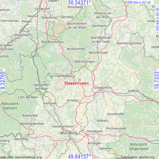
Wasserlosen GPS coordinates[2]
50° 5' 41.136" North, 10° 1' 48.612" East
| Map corner | latitude | longitude |
|---|---|---|
| Upper-left | 50.54371°, | 9.32705° |
| Center: | 50.09476°, | 10.03017° |
| Lower-right: | 49.64157°, | 10.7333° |
| Map W x H: | 100.3×100.3 km | = 62.3×62.3mi |
| max Lat: | 55.01917° ⇑61.5% North |
| Wasserlosen: | 50.09476° |
| min Lat: | ⇓38.5% South 47.40724° |
| min Long | Wasserlosen | max Long |
| 5.92978° | 10.03017° | 14.98853° |
| W 50.6%⇐ | ⇒49.4% E |
Elevation
Elevation of Wasserlosen is 340 m = 1115 ft, and this is 90.9 m = 298 ft above average elevation for this country.
| Max E: |
1256 m = 4121 ft | 32.4% |
| Wasserlosen | 340 m 1115 ft | |
| Avg. | 249.1 m = 817 ft | |
Min E: |
-5 m = -16 ft | 67.6% |
See also: Germany elevation on elevation.city.
Geographical zone
Wasserlosen is located in North temperate zone (between Tropic of Cancer and the Arctic Circle). Distance of this North polar circle is 1831.2 km =1137.9 mi to North.| Distance of | km | miles | from Wasserlosen |
|---|---|---|---|
| North Pole | 4437 | 2757 | to North |
| Arctic Circle | 1831.2 | 1137.9 | to North |
| Tropic Cancer | 2964.1 | 1841.8 | to South |
| Equator | 5570 | 3461 | to South |


Nearby cities:
15 places around Wasserlosen: (largest is in red/bold)
• Aura an der Saale
7.9 km =4.9 mi,  347°
347°
• Bad Kissingen
12.4 km =7.7 mi,  15°
15°
• Elfershausen
7.6 km =4.7 mi,  320°
320°
• Euerbach
8.4 km =5.2 mi,  115°
115°
• Euerdorf
6 km =3.7 mi,  355°
355°
• Fuchsstadt
7 km =4.3 mi,  282°
282°
• Geldersheim
10.7 km =6.6 mi, 122°
• Hammelburg
10.2 km =6.3 mi, 283°
• Niederwerrn
11.5 km =7.1 mi,  108°
108°
• Oberthulba
12.7 km =7.9 mi,  336°
336°
• Oerlenbach
9.6 km =6 mi,  50°
50°
• Poppenhausen
8 km =5 mi,  85°
85°
• Ramsthal
5.7 km =3.5 mi,  27°
27°
• Sulzthal
4.2 km =2.6 mi,  4°
4°
• Werneck
13.5 km =8.4 mi,  158°
158°
Sources, notices
• [Note1] Compared only with cities in Germany existing in our database
• [Src1] Map data: © OpenStreetMap contributors (CC-BY-SA)
• [Src2] Other city data from geonames.org with taken over terms of usage.
• [Src3] Geographical zone / Annual Mean Temperature by Robert A. Rohde @ Wikipedia
