Ramsthal geodata
Ramsthal (Bavaria) is a seat of a fourth-order administrative division; located in Germany in Europe/Berlin (GMT+2) time zone. With population of 1,212 people, there are 6533 cities with bigger population in this country. Compared to other cities in Germany, 60.3% of cities are located further ↑North; 51.2% of cities are located further ←West and 55% of cities have lower elevation than Ramsthal. Note1
Administrative division(s):
- Level 1: Bavaria
- Level 2: Regierungsbezirk Unterfranken
- Level 3: Landkreis Bad Kissingen
- Level 4: Ramsthal


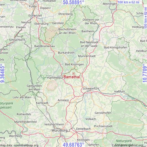
Ramsthal GPS coordinates[2]
50° 8' 25.404" North, 10° 4' 3.972" East
| Map corner | latitude | longitude |
|---|---|---|
| Upper-left | 50.58891°, | 9.36465° |
| Center: | 50.14039°, | 10.06777° |
| Lower-right: | 49.68763°, | 10.7709° |
| Map W x H: | 100.2×100.2 km | = 62.3×62.3mi |
| max Lat: | 55.01917° ⇑60.3% North |
| Ramsthal: | 50.14039° |
| min Lat: | ⇓39.7% South 47.40724° |
| min Long | Ramsthal | max Long |
| 5.92978° | 10.06777° | 14.98853° |
| W 51.2%⇐ | ⇒48.8% E |
Elevation
Elevation of Ramsthal is 258 m = 846 ft, and this is 8.9 m = 29 ft above average elevation for this country.
| Max E: |
1256 m = 4121 ft | 45% |
| Ramsthal | 258 m 846 ft | |
| Avg. | 249.1 m = 817 ft | |
Min E: |
-5 m = -16 ft | 55% |
See also: Germany elevation on elevation.city.
Geographical zone
Ramsthal is located in North temperate zone (between Tropic of Cancer and the Arctic Circle). Distance of this North polar circle is 1826.1 km =1134.7 mi to North.| Distance of | km | miles | from Ramsthal |
|---|---|---|---|
| North Pole | 4432 | 2753.9 | to North |
| Arctic Circle | 1826.1 | 1134.7 | to North |
| Tropic Cancer | 2969.2 | 1845 | to South |
| Equator | 5575.1 | 3464.2 | to South |


Nearby cities:
15 places around Ramsthal: (largest is in red/bold)
• Aura an der Saale
5.1 km =3.2 mi,  301°
301°
• Bad Kissingen
6.9 km =4.3 mi,  5°
5°
• Elfershausen
7.6 km =4.7 mi,  275°
275°
• Euerbach
10 km =6.2 mi,  150°
150°
• Euerdorf
3.3 km =2.1 mi,  285°
285°
• Fuchsstadt
10.2 km =6.3 mi,  249°
249°
• Geldersheim
12.5 km =7.8 mi, 149°
• Niederwerrn
12 km =7.5 mi,  136°
136°
• Nüdlingen
9.7 km =6 mi,  23°
23°
• Oberthulba
10.1 km =6.3 mi,  310°
310°
• Oerlenbach
4.8 km =3 mi,  77°
77°
• Poppenhausen
7 km =4.3 mi,  130°
130°
• Rannungen
10.2 km =6.3 mi,  74°
74°
• Sulzthal
2.5 km =1.6 mi, 249°
• Wasserlosen
5.7 km =3.5 mi,  207°
207°
Sources, notices
• [Note1] Compared only with cities in Germany existing in our database
• [Src1] Map data: © OpenStreetMap contributors (CC-BY-SA)
• [Src2] Other city data from geonames.org with taken over terms of usage.
• [Src3] Geographical zone / Annual Mean Temperature by Robert A. Rohde @ Wikipedia
