Bad Kissingen geodata
Bad Kissingen (Bavaria) is a seat of a third-order administrative division; located in Germany in Europe/Berlin (GMT+2) time zone. With population of 21,328 people, there are 717 cities with bigger population in this country. Compared to other cities in Germany, 58.9% of cities are located further ↑North; 51.3% of cities are located further ←West and 52.6% of cities have higher elevation than Bad Kissingen. Note1
Administrative division(s):
- Level 1: Bavaria
- Level 2: Regierungsbezirk Unterfranken
- Level 3: Landkreis Bad Kissingen
- Level 4: Bad Kissingen


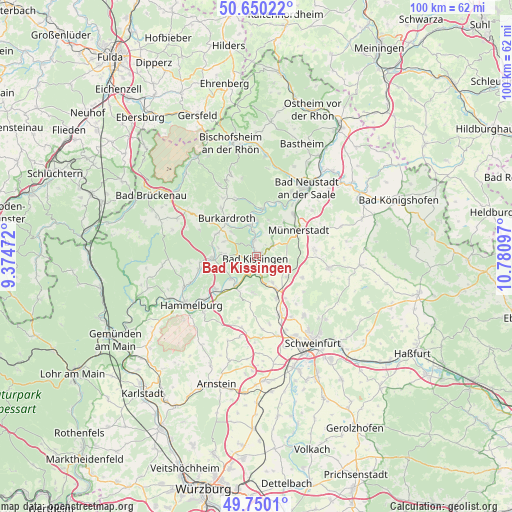
Bad Kissingen GPS coordinates[2]
50° 12' 8.208" North, 10° 4' 40.224" East
| Map corner | latitude | longitude |
|---|---|---|
| Upper-left | 50.65022°, | 9.37472° |
| Center: | 50.20228°, | 10.07784° |
| Lower-right: | 49.7501°, | 10.78097° |
| Map W x H: | 100.1×100.1 km | = 62.2×62.2mi |
| max Lat: | 55.01917° ⇑58.9% North |
| Bad Kissingen: | 50.20228° |
| min Lat: | ⇓41.1% South 47.40724° |
| min Long | Bad Kissingen | max Long |
| 5.92978° | 10.07784° | 14.98853° |
| W 51.3%⇐ | ⇒48.7% E |
Elevation
Elevation of Bad Kissingen is 207 m = 679 ft, and this is 42.1 m = 138 ft below average elevation for this country.
| Max E: |
1256 m = 4121 ft | 52.6% |
| Avg. | 249.1 m = 817 ft | |
| Bad Kissingen | 207 m = 679 ft | |
Min E: |
-5 m = -16 ft | 47.4% |
See also: Germany elevation on elevation.city.
Geographical zone
Bad Kissingen is located in North temperate zone (between Tropic of Cancer and the Arctic Circle). Distance of this North polar circle is 1819.2 km =1130.4 mi to North.| Distance of | km | miles | from Bad Kissingen |
|---|---|---|---|
| North Pole | 4425.1 | 2749.6 | to North |
| Arctic Circle | 1819.2 | 1130.4 | to North |
| Tropic Cancer | 2976.1 | 1849.3 | to South |
| Equator | 5582 | 3468.5 | to South |


Nearby cities:
15 places around Bad Kissingen: (largest is in red/bold)
• Aura an der Saale
6.6 km =4.1 mi,  229°
229°
• Bad Bocklet
7.1 km =4.4 mi,  0°
0°
• Burglauer
11 km =6.8 mi,  41°
41°
• Burkardroth
9.8 km =6.1 mi,  321°
321°
• Elfershausen
10.3 km =6.4 mi, 233°
• Euerdorf
7.1 km =4.4 mi,  213°
213°
• Münnerstadt
10.1 km =6.3 mi,  60°
60°
• Niederlauer
12.4 km =7.7 mi,  34°
34°
• Nüdlingen
3.8 km =2.4 mi, 57°
• Oberthulba
8.5 km =5.3 mi,  267°
267°
• Oerlenbach
7 km =4.3 mi,  145°
145°
• Poppenhausen
12.3 km =7.6 mi,  157°
157°
• Ramsthal
6.9 km =4.3 mi,  185°
185°
• Rannungen
9.9 km =6.2 mi,  114°
114°
• Sulzthal
8.4 km =5.2 mi,  201°
201°
Sources, notices
• [Note1] Compared only with cities in Germany existing in our database
• [Src1] Map data: © OpenStreetMap contributors (CC-BY-SA)
• [Src2] Other city data from geonames.org with taken over terms of usage.
• [Src3] Geographical zone / Annual Mean Temperature by Robert A. Rohde @ Wikipedia
