Walldürn geodata
Walldürn (Baden-Württemberg) is a populated place; located in Germany in Europe/Berlin (GMT+2) time zone. With population of 12,113 people, there are 1354 cities with bigger population in this country. Compared to other cities in Germany, 74.1% of cities are located further ↑North; 59.9% of cities are located further →East and 77.7% of cities have lower elevation than Walldürn. Note1
Administrative division(s):
- Level 1: Baden-Württemberg
- Level 2: Karlsruhe Region
- Level 3: Neckar-Odenwald-Kreis
- Level 4: Walldürn


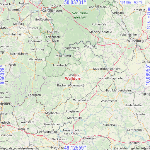
Walldürn GPS coordinates[2]
49° 35' 0.888" North, 9° 21' 59.112" East
| Map corner | latitude | longitude |
|---|---|---|
| Upper-left | 50.03731°, | 8.66329° |
| Center: | 49.58358°, | 9.36642° |
| Lower-right: | 49.12559°, | 10.06955° |
| Map W x H: | 101.4×101.4 km | = 63×63mi |
| max Lat: | 55.01917° ⇑74.1% North |
| Walldürn: | 49.58358° |
| min Lat: | ⇓25.9% South 47.40724° |
| min Long | Walldürn | max Long |
| 5.92978° | 9.36642° | 14.98853° |
| W 40.1%⇐ | ⇒59.9% E |
Elevation
Elevation of Walldürn is 417 m = 1368 ft, and this is 167.9 m = 551 ft above average elevation for this country.
| Max E: |
1256 m = 4121 ft | 22.3% |
| Walldürn | 417 m 1368 ft | |
| Avg. | 249.1 m = 817 ft | |
Min E: |
-5 m = -16 ft | 77.7% |
See also: Germany elevation on elevation.city.
Geographical zone
Walldürn is located in North temperate zone (between Tropic of Cancer and the Arctic Circle). Distance of this North polar circle is 1888 km =1173.1 mi to North.| Distance of | km | miles | from Walldürn |
|---|---|---|---|
| North Pole | 4493.9 | 2792.4 | to North |
| Arctic Circle | 1888 | 1173.1 | to North |
| Tropic Cancer | 2907.3 | 1806.5 | to South |
| Equator | 5513.2 | 3425.7 | to South |


Nearby cities:
15 places around Walldürn: (largest is in red/bold)
• Buch am Ahorn
14.5 km =9 mi,  109°
109°
• Buchen in Odenwald
7.3 km =4.5 mi,  205°
205°
• Bürgstadt
16.2 km =10.1 mi,  334°
334°
• Eichenbühl
13.8 km =8.6 mi,  348°
348°
• Hardheim
8.2 km =5.1 mi,  67°
67°
• Höpfingen
5 km =3.1 mi,  64°
64°
• Kirchzell
14.1 km =8.8 mi,  285°
285°
• Königheim
17 km =10.6 mi,  76°
76°
• Külsheim
14.8 km =9.2 mi,  49°
49°
• Miltenberg
15.2 km =9.4 mi, 332°
• Mudau
12.9 km =8 mi,  244°
244°
• Neunkirchen
14 km =8.7 mi,  10°
10°
• Rosenberg
16.2 km =10.1 mi,  151°
151°
• Seckach
15.9 km =9.9 mi,  188°
188°
• Weilbach
14.3 km =8.9 mi,  311°
311°
Sources, notices
• [Note1] Compared only with cities in Germany existing in our database
• [Src1] Map data: © OpenStreetMap contributors (CC-BY-SA)
• [Src2] Other city data from geonames.org with taken over terms of usage.
• [Src3] Geographical zone / Annual Mean Temperature by Robert A. Rohde @ Wikipedia
