Buchen in Odenwald geodata
Buchen in Odenwald (Baden-Württemberg) is a populated place; located in Germany in Europe/Berlin (GMT+2) time zone. With population of 18,890 people, there are 828 cities with bigger population in this country. Compared to other cities in Germany, 75.3% of cities are located further ↑North; 60.4% of cities are located further →East and 68.2% of cities have lower elevation than Buchen in Odenwald. Note1
Administrative division(s):
- Level 1: Baden-Württemberg
- Level 2: Karlsruhe Region
- Level 3: Neckar-Odenwald-Kreis
- Level 4: Buchen (Odenwald)


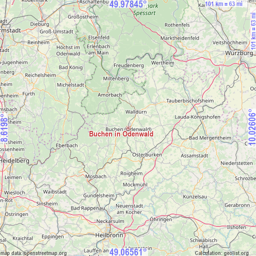
Buchen in Odenwald GPS coordinates[2]
49° 31' 26.976" North, 9° 19' 22.548" East
| Map corner | latitude | longitude |
|---|---|---|
| Upper-left | 49.97845°, | 8.6198° |
| Center: | 49.52416°, | 9.32293° |
| Lower-right: | 49.06561°, | 10.02606° |
| Map W x H: | 101.5×101.5 km | = 63.1×63.1mi |
| max Lat: | 55.01917° ⇑75.3% North |
| Buchen in Odenwald: | 49.52416° |
| min Lat: | ⇓24.7% South 47.40724° |
| min Long | Buchen in Odenw | max Long |
| 5.92978° | 9.32293° | 14.98853° |
| W 39.6%⇐ | ⇒60.4% E |
Elevation
Elevation of Buchen in Odenwald is 344 m = 1129 ft, and this is 94.9 m = 311 ft above average elevation for this country.
| Max E: |
1256 m = 4121 ft | 31.8% |
| Buchen in Odenwald | 344 m 1129 ft | |
| Avg. | 249.1 m = 817 ft | |
Min E: |
-5 m = -16 ft | 68.2% |
See also: Germany elevation on elevation.city.
Geographical zone
Buchen in Odenwald is located in North temperate zone (between Tropic of Cancer and the Arctic Circle). Distance of this North polar circle is 1894.6 km =1177.2 mi to North.| Distance of | km | miles | from Buchen in Odenwald |
|---|---|---|---|
| North Pole | 4500.5 | 2796.5 | to North |
| Arctic Circle | 1894.6 | 1177.2 | to North |
| Tropic Cancer | 2900.7 | 1802.4 | to South |
| Equator | 5506.6 | 3421.6 | to South |


Nearby cities:
15 places around Buchen in Odenwald: (largest is in red/bold)
• Adelsheim
14.5 km =9 mi,  159°
159°
• Buch am Ahorn
16.9 km =10.5 mi,  84°
84°
• Fahrenbach
16.2 km =10.1 mi,  230°
230°
• Hardheim
14.5 km =9 mi,  47°
47°
• Hesseneck
19.4 km =12.1 mi,  285°
285°
• Höpfingen
11.6 km =7.2 mi,  41°
41°
• Kirchzell
14.8 km =9.2 mi,  314°
314°
• Limbach
10.6 km =6.6 mi, 229°
• Mudau
8.6 km =5.3 mi,  277°
277°
• Osterburken
12.7 km =7.9 mi,  145°
145°
• Roigheim
17.8 km =11.1 mi,  176°
176°
• Rosenberg
13.2 km =8.2 mi,  125°
125°
• Seckach
9.1 km =5.7 mi,  174°
174°
• Walldürn
7.3 km =4.5 mi,  25°
25°
• Weilbach
17.8 km =11.1 mi,  334°
334°
Sources, notices
• [Note1] Compared only with cities in Germany existing in our database
• [Src1] Map data: © OpenStreetMap contributors (CC-BY-SA)
• [Src2] Other city data from geonames.org with taken over terms of usage.
• [Src3] Geographical zone / Annual Mean Temperature by Robert A. Rohde @ Wikipedia
