Kirchzell geodata
Kirchzell (Bavaria) is a populated place; located in Germany in Europe/Berlin (GMT+2) time zone. With population of 2,468 people, there are 4476 cities with bigger population in this country. Compared to other cities in Germany, 73.3% of cities are located further ↑North; 62.8% of cities are located further →East and 54% of cities have higher elevation than Kirchzell. Note1
Administrative division(s):
- Level 1: Bavaria
- Level 2: Regierungsbezirk Unterfranken
- Level 3: Landkreis Miltenberg
- Level 4: Kirchzell, Markt


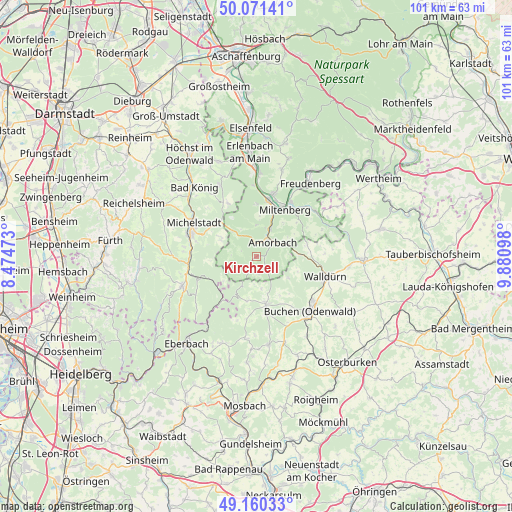
Kirchzell GPS coordinates[2]
49° 37' 4.8" North, 9° 10' 40.26" East
| Map corner | latitude | longitude |
|---|---|---|
| Upper-left | 50.07141°, | 8.47473° |
| Center: | 49.618°, | 9.17785° |
| Lower-right: | 49.16033°, | 9.88098° |
| Map W x H: | 101.3×101.3 km | = 62.9×62.9mi |
| max Lat: | 55.01917° ⇑73.3% North |
| Kirchzell: | 49.618° |
| min Lat: | ⇓26.7% South 47.40724° |
| min Long | Kirchzell | max Long |
| 5.92978° | 9.17785° | 14.98853° |
| W 37.2%⇐ | ⇒62.8% E |
Elevation
Elevation of Kirchzell is 197 m = 646 ft, and this is 52.1 m = 171 ft below average elevation for this country.
| Max E: |
1256 m = 4121 ft | 54% |
| Avg. | 249.1 m = 817 ft | |
| Kirchzell | 197 m = 646 ft | |
Min E: |
-5 m = -16 ft | 46% |
See also: Germany elevation on elevation.city.
Geographical zone
Kirchzell is located in North temperate zone (between Tropic of Cancer and the Arctic Circle). Distance of this North polar circle is 1884.2 km =1170.8 mi to North.| Distance of | km | miles | from Kirchzell |
|---|---|---|---|
| North Pole | 4490.1 | 2790 | to North |
| Arctic Circle | 1884.2 | 1170.8 | to North |
| Tropic Cancer | 2911.1 | 1808.9 | to South |
| Equator | 5517 | 3428.1 | to South |


Nearby cities:
15 places around Kirchzell: (largest is in red/bold)
• Buchen in Odenwald
14.8 km =9.2 mi,  134°
134°
• Bürgstadt
12.6 km =7.8 mi,  31°
31°
• Eichenbühl
14.6 km =9.1 mi,  48°
48°
• Erbach
14.1 km =8.8 mi,  290°
290°
• Großheubach
12.7 km =7.9 mi,  14°
14°
• Hesseneck
9.9 km =6.2 mi,  237°
237°
• Kleinheubach
11.7 km =7.3 mi, 12°
• Laudenbach
14.2 km =8.8 mi,  359°
359°
• Michelstadt
14.1 km =8.8 mi,  297°
297°
• Miltenberg
11.6 km =7.2 mi, 33°
• Mudau
9.5 km =5.9 mi,  168°
168°
• Rüdenau
10.4 km =6.5 mi,  0°
0°
• Walldürn
14.1 km =8.8 mi,  105°
105°
• Weilbach
6.2 km =3.9 mi, 26°
• Weiten-Gesäß
13.1 km =8.1 mi,  315°
315°
Sources, notices
• [Note1] Compared only with cities in Germany existing in our database
• [Src1] Map data: © OpenStreetMap contributors (CC-BY-SA)
• [Src2] Other city data from geonames.org with taken over terms of usage.
• [Src3] Geographical zone / Annual Mean Temperature by Robert A. Rohde @ Wikipedia
