Rosenberg geodata
Rosenberg (Baden-Württemberg) is a seat of a fourth-order administrative division; located in Germany in Europe/Berlin (GMT+2) time zone. In our database, there are 11009 cities with bigger population. Compared to other cities in Germany, 76.4% of cities are located further ↑North; 58.2% of cities are located further →East and 59.3% of cities have lower elevation than Rosenberg. Note1
Administrative division(s):
- Level 1: Baden-Württemberg
- Level 2: Karlsruhe Region
- Level 3: Neckar-Odenwald-Kreis
- Level 4: Rosenberg


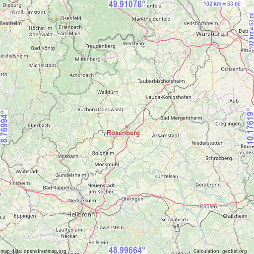
Rosenberg GPS coordinates[2]
49° 27' 20.988" North, 9° 28' 23.016" East
| Map corner | latitude | longitude |
|---|---|---|
| Upper-left | 49.91076°, | 8.76994° |
| Center: | 49.45583°, | 9.47306° |
| Lower-right: | 48.99664°, | 10.17619° |
| Map W x H: | 101.6×101.6 km | = 63.1×63.1mi |
| max Lat: | 55.01917° ⇑76.4% North |
| Rosenberg: | 49.45583° |
| min Lat: | ⇓23.6% South 47.40724° |
| min Long | Rosenberg | max Long |
| 5.92978° | 9.47306° | 14.98853° |
| W 41.8%⇐ | ⇒58.2% E |
Elevation
Elevation of Rosenberg is 285 m = 935 ft, and this is 35.9 m = 118 ft above average elevation for this country.
| Max E: |
1256 m = 4121 ft | 40.7% |
| Rosenberg | 285 m 935 ft | |
| Avg. | 249.1 m = 817 ft | |
Min E: |
-5 m = -16 ft | 59.3% |
See also: Germany elevation on elevation.city.
Geographical zone
Rosenberg is located in North temperate zone (between Tropic of Cancer and the Arctic Circle). Distance of this North polar circle is 1902.2 km =1182 mi to North.| Distance of | km | miles | from Rosenberg |
|---|---|---|---|
| North Pole | 4508.1 | 2801.2 | to North |
| Arctic Circle | 1902.2 | 1182 | to North |
| Tropic Cancer | 2893.1 | 1797.7 | to South |
| Equator | 5499 | 3416.9 | to South |


Nearby cities:
15 places around Rosenberg: (largest is in red/bold)
• Adelsheim
8.4 km =5.2 mi,  223°
223°
• Assamstadt
15.7 km =9.8 mi,  101°
101°
• Boxberg
12.4 km =7.7 mi,  77°
77°
• Buch am Ahorn
11 km =6.8 mi,  32°
32°
• Buchen in Odenwald
13.2 km =8.2 mi,  305°
305°
• Hardheim
17.4 km =10.8 mi,  359°
359°
• Höpfingen
16.6 km =10.3 mi,  348°
348°
• Jagsthausen
16.2 km =10.1 mi,  181°
181°
• Krautheim
14 km =8.7 mi,  122°
122°
• Möckmühl
16.8 km =10.4 mi,  209°
209°
• Osterburken
4.6 km =2.9 mi,  231°
231°
• Roigheim
14 km =8.7 mi, 223°
• Seckach
10.2 km =6.3 mi,  261°
261°
• Walldürn
16.2 km =10.1 mi,  331°
331°
• Widdern
15.7 km =9.8 mi,  193°
193°
Sources, notices
• [Note1] Compared only with cities in Germany existing in our database
• [Src1] Map data: © OpenStreetMap contributors (CC-BY-SA)
• [Src2] Other city data from geonames.org with taken over terms of usage.
• [Src3] Geographical zone / Annual Mean Temperature by Robert A. Rohde @ Wikipedia
