Walldorf geodata
Walldorf (Baden-Württemberg) is a populated place; located in Germany in Europe/Berlin (GMT+2) time zone. With population of 14,842 people, there are 1071 cities with bigger population in this country. Compared to other cities in Germany, 78.5% of cities are located further ↑North; 69.7% of cities are located further →East and 67.4% of cities have higher elevation than Walldorf. Note1
Administrative division(s):
- Level 1: Baden-Württemberg
- Level 2: Karlsruhe Region
- Level 3: Rhein-Neckar-Kreis
- Level 4: Walldorf


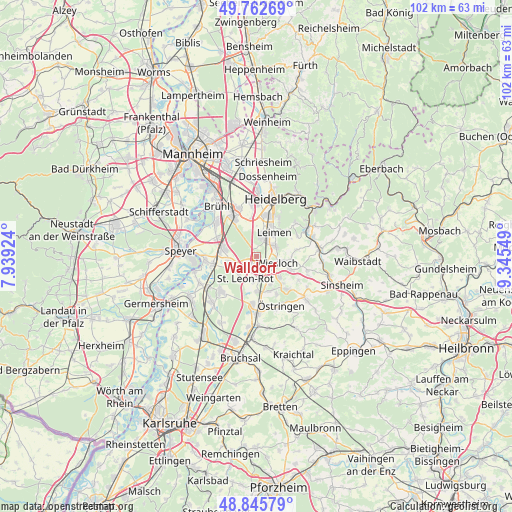
Walldorf GPS coordinates[2]
49° 18' 22.932" North, 8° 38' 32.496" East
| Map corner | latitude | longitude |
|---|---|---|
| Upper-left | 49.76269°, | 7.93924° |
| Center: | 49.30637°, | 8.64236° |
| Lower-right: | 48.84579°, | 9.34549° |
| Map W x H: | 101.9×101.9 km | = 63.3×63.3mi |
| max Lat: | 55.01917° ⇑78.5% North |
| Walldorf: | 49.30637° |
| min Lat: | ⇓21.5% South 47.40724° |
| min Long | Walldorf | max Long |
| 5.92978° | 8.64236° | 14.98853° |
| W 30.3%⇐ | ⇒69.7% E |
Elevation
Elevation of Walldorf is 105 m = 344 ft, and this is 144.1 m = 473 ft below average elevation for this country.
| Max E: |
1256 m = 4121 ft | 67.4% |
| Avg. | 249.1 m = 817 ft | |
| Walldorf | 105 m = 344 ft | |
Min E: |
-5 m = -16 ft | 32.6% |
See also: Germany elevation on elevation.city.
Geographical zone
Walldorf is located in North temperate zone (between Tropic of Cancer and the Arctic Circle). Distance of this North polar circle is 1918.8 km =1192.3 mi to North.| Distance of | km | miles | from Walldorf |
|---|---|---|---|
| North Pole | 4524.7 | 2811.5 | to North |
| Arctic Circle | 1918.8 | 1192.3 | to North |
| Tropic Cancer | 2876.4 | 1787.3 | to South |
| Equator | 5482.4 | 3406.6 | to South |


Nearby cities:
15 places around Walldorf: (largest is in red/bold)
• Dielheim
7.4 km =4.6 mi,  109°
109°
• Hockenheim
6.8 km =4.2 mi,  286°
286°
• Kronau
9.4 km =5.8 mi,  185°
185°
• Leimen
5.6 km =3.5 mi,  35°
35°
• Malsch
7.2 km =4.5 mi,  155°
155°
• Mühlhausen
8.9 km =5.5 mi,  136°
136°
• Neulußheim
9 km =5.6 mi,  264°
264°
• Nußloch
4.3 km =2.7 mi,  63°
63°
• Oftersheim
7.8 km =4.8 mi,  326°
326°
• Rauenberg
6 km =3.7 mi,  132°
132°
• Reilingen
5.7 km =3.5 mi, 261°
• Sandhausen
4.2 km =2.6 mi,  16°
16°
• Sankt Leon-Rot
4.8 km =3 mi,  201°
201°
• Schwetzingen
9.5 km =5.9 mi, 332°
• Wiesloch
4.3 km =2.7 mi, 107°
Sources, notices
• [Note1] Compared only with cities in Germany existing in our database
• [Src1] Map data: © OpenStreetMap contributors (CC-BY-SA)
• [Src2] Other city data from geonames.org with taken over terms of usage.
• [Src3] Geographical zone / Annual Mean Temperature by Robert A. Rohde @ Wikipedia
