Kronau geodata
Kronau (Baden-Württemberg) is a seat of a fourth-order administrative division; located in Germany in Europe/Berlin (GMT+2) time zone. With population of 5,585 people, there are 2599 cities with bigger population in this country. Compared to other cities in Germany, 80% of cities are located further ↑North; 69.8% of cities are located further →East and 66.9% of cities have higher elevation than Kronau. Note1
Administrative division(s):
- Level 1: Baden-Württemberg
- Level 2: Karlsruhe Region
- Level 3: Landkreis Karlsruhe
- Level 4: Kronau


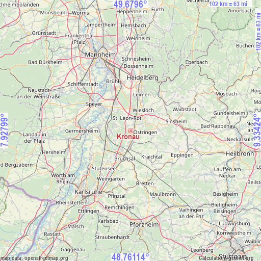
Kronau GPS coordinates[2]
49° 13' 21" North, 8° 37' 51.996" East
| Map corner | latitude | longitude |
|---|---|---|
| Upper-left | 49.6796°, | 7.92799° |
| Center: | 49.2225°, | 8.63111° |
| Lower-right: | 48.76114°, | 9.33424° |
| Map W x H: | 102.1×102.1 km | = 63.4×63.4mi |
| max Lat: | 55.01917° ⇑80% North |
| Kronau: | 49.2225° |
| min Lat: | ⇓20% South 47.40724° |
| min Long | Kronau | max Long |
| 5.92978° | 8.63111° | 14.98853° |
| W 30.2%⇐ | ⇒69.8% E |
Elevation
Elevation of Kronau is 109 m = 358 ft, and this is 140.1 m = 460 ft below average elevation for this country.
| Max E: |
1256 m = 4121 ft | 66.9% |
| Avg. | 249.1 m = 817 ft | |
| Kronau | 109 m = 358 ft | |
Min E: |
-5 m = -16 ft | 33.1% |
See also: Germany elevation on elevation.city.
Geographical zone
Kronau is located in North temperate zone (between Tropic of Cancer and the Arctic Circle). Distance of this North polar circle is 1928.1 km =1198.1 mi to North.| Distance of | km | miles | from Kronau |
|---|---|---|---|
| North Pole | 4534 | 2817.3 | to North |
| Arctic Circle | 1928.1 | 1198.1 | to North |
| Tropic Cancer | 2867.1 | 1781.5 | to South |
| Equator | 5473 | 3400.8 | to South |


Nearby cities:
15 places around Kronau: (largest is in red/bold)
• Bruchsal
11.2 km =7 mi,  192°
192°
• Dielheim
10.4 km =6.5 mi,  48°
48°
• Forst
8 km =5 mi,  207°
207°
• Hambrücken
7.5 km =4.7 mi,  241°
241°
• Kraichtal
11.2 km =7 mi,  138°
138°
• Malsch
4.7 km =2.9 mi, 53°
• Mühlhausen
7.5 km =4.7 mi,  67°
67°
• Rauenberg
7.4 km =4.6 mi, 45°
• Reilingen
9.7 km =6 mi,  330°
330°
• Sankt Leon-Rot
4.9 km =3 mi,  348°
348°
• Ubstadt-Weiher
6.6 km =4.1 mi,  179°
179°
• Waghäusel
9.1 km =5.7 mi,  289°
289°
• Walldorf
9.4 km =5.8 mi,  5°
5°
• Wiesloch
9.4 km =5.8 mi,  31°
31°
• Östringen
5.9 km =3.7 mi,  93°
93°
Sources, notices
• [Note1] Compared only with cities in Germany existing in our database
• [Src1] Map data: © OpenStreetMap contributors (CC-BY-SA)
• [Src2] Other city data from geonames.org with taken over terms of usage.
• [Src3] Geographical zone / Annual Mean Temperature by Robert A. Rohde @ Wikipedia
