Rauenberg geodata
Rauenberg (Baden-Württemberg) is a populated place; located in Germany in Europe/Berlin (GMT+2) time zone. With population of 7,411 people, there are 2091 cities with bigger population in this country. Compared to other cities in Germany, 79.2% of cities are located further ↑North; 69% of cities are located further →East and 63.2% of cities have higher elevation than Rauenberg. Note1
Administrative division(s):
- Level 1: Baden-Württemberg
- Level 2: Karlsruhe Region
- Level 3: Rhein-Neckar-Kreis
- Level 4: Rauenberg


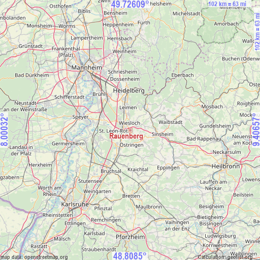
Rauenberg GPS coordinates[2]
49° 16' 9.948" North, 8° 42' 12.384" East
| Map corner | latitude | longitude |
|---|---|---|
| Upper-left | 49.72609°, | 8.00032° |
| Center: | 49.26943°, | 8.70344° |
| Lower-right: | 48.8085°, | 9.40657° |
| Map W x H: | 102×102 km | = 63.4×63.4mi |
| max Lat: | 55.01917° ⇑79.2% North |
| Rauenberg: | 49.26943° |
| min Lat: | ⇓20.8% South 47.40724° |
| min Long | Rauenberg | max Long |
| 5.92978° | 8.70344° | 14.98853° |
| W 31%⇐ | ⇒69% E |
Elevation
Elevation of Rauenberg is 131 m = 430 ft, and this is 118.1 m = 387 ft below average elevation for this country.
| Max E: |
1256 m = 4121 ft | 63.2% |
| Avg. | 249.1 m = 817 ft | |
| Rauenberg | 131 m = 430 ft | |
Min E: |
-5 m = -16 ft | 36.8% |
See also: Germany elevation on elevation.city.
Geographical zone
Rauenberg is located in North temperate zone (between Tropic of Cancer and the Arctic Circle). Distance of this North polar circle is 1922.9 km =1194.8 mi to North.| Distance of | km | miles | from Rauenberg |
|---|---|---|---|
| North Pole | 4528.8 | 2814.1 | to North |
| Arctic Circle | 1922.9 | 1194.8 | to North |
| Tropic Cancer | 2872.3 | 1784.8 | to South |
| Equator | 5478.2 | 3404 | to South |


Nearby cities:
15 places around Rauenberg: (largest is in red/bold)
• Balzfeld
6.2 km =3.9 mi,  90°
90°
• Dielheim
3 km =1.9 mi,  56°
56°
• Horrenberg
5.7 km =3.5 mi,  77°
77°
• Kronau
7.4 km =4.6 mi,  225°
225°
• Leimen
8.7 km =5.4 mi,  352°
352°
• Malsch
2.9 km =1.8 mi,  211°
211°
• Meckesheim
10.2 km =6.3 mi, 55°
• Mühlhausen
2.9 km =1.8 mi,  143°
143°
• Nußloch
6.1 km =3.8 mi, 354°
• Sandhausen
8.8 km =5.5 mi,  338°
338°
• Sankt Leon-Rot
6.2 km =3.9 mi,  266°
266°
• Walldorf
6 km =3.7 mi,  312°
312°
• Wiesloch
2.9 km =1.8 mi, 352°
• Zuzenhausen
9.1 km =5.7 mi,  70°
70°
• Östringen
5.6 km =3.5 mi,  173°
173°
Sources, notices
• [Note1] Compared only with cities in Germany existing in our database
• [Src1] Map data: © OpenStreetMap contributors (CC-BY-SA)
• [Src2] Other city data from geonames.org with taken over terms of usage.
• [Src3] Geographical zone / Annual Mean Temperature by Robert A. Rohde @ Wikipedia
